Inajá, Pernambuco
Inajá | |
|---|---|
 Church of Saint Anthony of Padua | |
 Flag | |
| Etymology: Derived from indigenous origin meaning "small palm tree", referring to the carnauba trees on the banks of the Moxotó River[1] | |
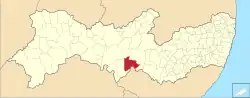 Location of Inajá in Pernambuco | |
 Inajá  Inajá | |
| Coordinates: 8°54′11″S 37°49′37″W / 8.90306°S 37.82694°W | |
| Country | |
| Region | Northeast |
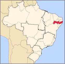
| State | |
| Founded | 2 January 1949[3] |
| Government | |
| • Mayor | Marcelo Machado Freire (Republicanos) (2025-2028)[4][5] |
| • Vice Mayor | Rafael Antônio de Araujo (Avante) (2025-2028)[4][5] |
| Area | |
• Total | 1,240.961 km2 (479.138 sq mi) |
| Elevation | 355 m (1,165 ft) |
| Population (2022) | |
• Total | 25,603[2] |
| • Density | 20.79/km2 (53.8/sq mi) |
| Demonym | Inajaense (Brazilian Portuguese)[2] |
| Time zone | UTC-03:00 (Brasília Time) |
| Postal code | 56560-000[6] |
| HDI (2010) | 0.523 – low[2] |
| Website | inaja.pe.gov.br |
Inajá is a city in the state of Pernambuco, Brazil. The population in 2020, according with IBGE was 23,645 inhabitants and the total area is 1168.16 km².[7]
Geography
- State - Pernambuco
- Region - Sertão Pernambucano
- Boundaries - Floresta and Ibimirim (N); Tacaratu and Alagoas state (S); Manari (E); Tacaratu (W).
- Area - 1182.16 km²
- Elevation - 355 m
- Hydrography - Moxotó River
- Vegetation - Caatinga hiperxerófila
- Climate - semi arid - (Sertão) hot
- Annual average temperature - 25.3 c
- Distance to Recife - 412.4 km
The municipality contains part of the 625 hectares (1,540 acres) Serra Negra Biological Reserve, a strictly protected conservation unit created in 1982.[8]
Economy
The main economic activities in Inajá are based in commerce and agribusiness, especially creation of goats, sheep, cattle, pigs, horses, chickens; and plantations of tomatoes and water melons.
Economic Indicators
| Population [9] | GDP x(1000 R$).[10] | GDP pc (R$) | PE |
|---|---|---|---|
| 14.729 | 52.704 | 3.755 | 0.088% |
Economy by Sector 2006
| Primary sector | Secondary sector | Service sector |
|---|---|---|
| 23.65% | 6.94% | 69.41% |
Health Indicators
| HDI (2000) | Hospitals (2007) | Hospitals beds (2007) | Children's Mortality every 1000 (2005) |
|---|---|---|---|
| 0.566 | 1 | 13 | 39.4 |
See also
References
- ^ "Inajá". Prefeitura Municipal de Inajá (in Brazilian Portuguese). Prefeitura Municipal de Inajá. Archived from the original on 12 September 2024. Retrieved 5 February 2025.
- ^ a b c "Inajá". Instituto Brasileiro de Geografia e Estatística (in Brazilian Portuguese). Instituto Brasileiro de Geografia e Estatística. Retrieved 5 February 2025.
- ^ Coelho, Antonio (26 April 2019). "Indicação No 1030/2019". Assembleia Legislativa do Estado de Pernambuco (in Brazilian Portuguese). Assembleia Legislativa do Estado de Pernambuco. Retrieved 4 February 2025.
- ^ a b "Eleições 2024: Marcelo de Alberto (REPUBLICANOS) | Candidato(a) a prefeito(a) de Inajá-PE". Folha de S.Paulo (in Brazilian Portuguese). Folha de S.Paulo. 30 November 2024. Retrieved 4 February 2025.
- ^ a b "Prefeito de Inajá (PE) toma posse nesta quarta (1º); veja lista de vereadores eleitos". G1 (in Brazilian Portuguese). Globo. 31 December 2024. Retrieved 4 February 2025.
- ^ "CEP Inajá/PE - Brasil". codigo-postal.org (in Brazilian Portuguese). codigo-postal.org. Retrieved 5 February 2025.
- ^ IBGE 2020
- ^ Unidade de Conservação: Reserva Biológica de Serra Negra (in Portuguese), MMA: Ministério do Meio Ambiente, retrieved 17 April 2016
{{citation}}: CS1 maint: publisher location (link) - ^ http://www.ibge.gov.br/home/estatistica/populacao/estimativa2009/POP2009_DOU.pdfIBGE Population Inajá 2009, page 33
- ^ Inajá 2007 GDP IBGE page 30 Archived 4 March 2016 at the Wayback Machine
- ^ "PE State site - City by city profile". Archived from the original on 4 August 2009. Retrieved 20 August 2009.
Capital: Recife | ||||||||||||||
| Mesoregion Agreste Pernambucano |
|  | ||||||||||||
| Mesoregion Mata Pernambucana |
| |||||||||||||
| Mesoregion Metropolitana de Recife |
| |||||||||||||
| Mesoregion Sao Francisco Pernambucano |
| |||||||||||||
| Mesoregion Sertão Pernambucano |
| |||||||||||||