Santa Terezinha, Pernambuco
Santa Terezinha | |
|---|---|
 Santa Terezinha | |
 Flag  Coat of arms | |
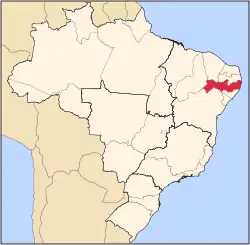
 Location of Santa Terezinha in Pernambuco | |
 Santa Terezinha  Santa Terezinha | |
| Coordinates: 7°22′40″S 37°28′48″W / 7.37778°S 37.48000°W | |
| Country | |
| Region | Northeast |
| State | |
| Founded | 20 December 1963[2] |
| Government | |
| • Mayor | Adeilson Lustosa da Silva (PODE) (2025-2028)[3][4] |
| • Vice Mayor | Jaizinho Ferreira de Andrade (PSB) (2025-2028)[3][4] |
| Area | |
• Total | 200.327 km2 (77.347 sq mi) |
| Elevation | 813 m (2,667 ft) |
| Population (2022) | |
• Total | 10,244[1] |
| • Density | 51.14/km2 (132.5/sq mi) |
| Demonym | Santa-terezinhense (Brazilian Portuguese)[1] |
| Time zone | UTC-03:00 (Brasília Time) |
| Postal code | 56750-000[5] |
| HDI (2010) | 0.593 – medium[1] |
| Website | santaterezinha.pe.gov.br |
Santa Terezinha is a city in the state of Pernambuco, Brazil. The population in 2020, according with IBGE was 11,865 inhabitants and the total area is 200.32 km².[6]
Geography
- State - Pernambuco
- Region - Sertão Pernambucano
- Boundaries - Paraíba state and Brejinho (N); São José do Egito and Tabira (S); São José do Egito (E); Tabira (W).
- Area - 195.58 km²
- Elevation - 813 m
- Hydrography - Pajeú River
- Vegetation - Caatinga
- Climate - Semi arid and tropical hot
- Annual average temperature - 21.7 c
- Distance to Recife - 429.5 km
Economy
The main economic activities in Santa Terezinha are based in agribusiness, especially creation of cattle, sheep, pigss, goats, chickens; and plantations of beans, corn and manioc.
Economic Indicators
| Population [7] | GDP x(1000 R$).[8] | GDP pc (R$) | PE |
|---|---|---|---|
| 10.184 | 29.224 | 2.942 | 0.05% |
Economy by Sector 2006
| Primary sector | Secondary sector | Service sector |
|---|---|---|
| 12.53% | 8.98% | 78.49% |
Health Indicators
| HDI (2000) | Hospitals (2007) | Hospitals beds (2007) | Children's Mortality every 1000 (2005) |
|---|---|---|---|
| 0.602 | 1 | 10 | 29.3 |
See also
References
- ^ a b c "Santa Terezinha". Instituto Brasileiro de Geografia e Estatística (in Brazilian Portuguese). Instituto Brasileiro de Geografia e Estatística. Retrieved 17 March 2025.
- ^ "História & Fotos". Instituto Brasileiro de Geografia e Estatística (in Brazilian Portuguese). Instituto Brasileiro de Geografia e Estatística. Retrieved 17 March 2025.
- ^ a b "Eleições 2024: Delson Lustosa (PODE) | Candidato(a) a prefeito(a) de Santa Terezinha-PE". Folha de S.Paulo (in Brazilian Portuguese). Folha de S.Paulo. 30 November 2024. Retrieved 17 March 2025.
- ^ a b "Prefeito de Santa Terezinha (PE) toma posse nesta quarta (1º); veja lista de vereadores eleitos". G1 (in Brazilian Portuguese). Globo. 31 December 2024. Retrieved 17 March 2025.
- ^ "CEP Santa Terezinha/PE - Brasil". codigo-postal.org (in Brazilian Portuguese). codigo-postal.org. Retrieved 17 March 2025.
- ^ IBGE 2020
- ^ http://www.ibge.gov.br/home/estatistica/populacao/estimativa2009/POP2009_DOU.pdfIBGE Population Santa Terezinha 2009, page 35
- ^ Santa Terezinha 2007 GDP IBGE page 32 Archived 4 March 2016 at the Wayback Machine
- ^ PE State site - City by city profile
Capital: Recife | ||||||||||||||
| Mesoregion Agreste Pernambucano |
|  | ||||||||||||
| Mesoregion Mata Pernambucana |
| |||||||||||||
| Mesoregion Metropolitana de Recife |
| |||||||||||||
| Mesoregion Sao Francisco Pernambucano |
| |||||||||||||
| Mesoregion Sertão Pernambucano |
| |||||||||||||