Itapuã do Oeste
Itapuã do Oeste | |
|---|---|
Municipality | |
 | |
 Flag  Seal | |
 Itapuã do Oeste | |
| Coordinates: 9°11′06″S 63°11′10″W / 9.185°S 63.186°W | |
| Country | Brazil |
| State | Rondônia |
| Municipality | Itapuã do Oeste |
| Population (2020 [1]) | |
• Total | 10,641 |
| Time zone | UTC−4 (AMT) |
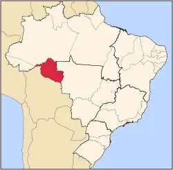
Itapuã do Oeste is a municipality located in the Brazilian state of Rondônia. Its population was 10,641 (2020) and its area is 4,081 km².[2]
The municipality contains 24% of the fully protected 71,161 hectares (175,840 acres) Samuel Ecological Station.[3]
See also
References
- ^ IBGE 2020
- ^ IBGE - "Archived copy". Archived from the original on 2007-01-09. Retrieved 2014-08-03.
{{cite web}}: CS1 maint: archived copy as title (link) - ^ Samuel Estação Ecológica (in Portuguese), ISA: Instituto Socioambiental, retrieved 2016-05-14
{{citation}}: CS1 maint: publisher location (link)