Kopargaon taluka
Kopargaon taluka | |
|---|---|
.jpg) Sanjivani College of Engineering in Kopargaon | |
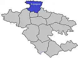 Location of Kopargaon in Ahmednagar district in Maharashtra | |
| Country | |
| State | Maharashtra |
| District | Ahmednagar |
| Headquarters | Kopargaon |
| Area | |
• Total | 725.16 km2 (279.99 sq mi) |
| Population (2011) | |
• Total | 302,452 |
| • Density | 420/km2 (1,100/sq mi) |
| Demographics | |
| • Literacy rate | 85.08 |
| • Sex ratio | 965 |
Kopargaon taluka is a taluka in Shirdi subdivision of Ahmednagar district in Maharashtra state of India.[1]
Area
The table below shows area of the taluka by land type.[2]
| Type of Land | Area (km2) | % of Total Area |
|---|---|---|
| Agriculture | 686.47 | 94.66 |
| Forest | 0 | 0 |
| Other | 38.69 | 5.34 |
| Total | 725.16 | 100 |
Villages
There are around 79 villages in Kopargaon taluka. For a list of villages see Villages in Kopargaon taluka. Major villages include Karanji bk, Kolapewadi, Manjur, Chas Nali, Sanwaster, Pohegaon, Dhamori, Dauch Khurd, Sangvi Bhusar, and Rawanda.
Population
Kopargaon taluka has a population of 302,452 according to the 2011 census. Kopargaon had a literacy rate of 69.75% and a sex ratio of 942 females per 1000 males. 65,273 (21.58%) lived in urban areas. Scheduled Castes and Scheduled Tribes make up 13.36% and 11.37% of the population respectively.[4]
At the time of the 2011 Census of India, 88.86% of the population in the district spoke Marathi, 5.26% Hindi and 3.01% Urdu as their first language.[5]
Rainfall
The Table below details rainfall from 1981 to 2004.[6]
| Year | Rainfall (mm) |
|---|---|
| 1981 | 421 |
| 1982 | 389 |
| 1983 | 531 |
| 1984 | 518 |
| 1985 | 300 |
| 1986 | 319 |
| 1987 | 460 |
| 1988 | 575 |
| 1989 | 594 |
| 1990 | 499 |
| 1991 | 296 |
| 1992 | 418 |
| 1993 | 408 |
| 1994 | 440.2 |
| 1995 | 321 |
| 1996 | 537 |
| 1997 | 290 |
| 1998 | 582 |
| 1999 | 384 |
| 2000 | 428 |
| 2001 | 360 |
| 2002 | 366 |
| 2003 | 280 |
| 2004 | 400 |
See also
References
- ^ "Talukas in Ahmednagar district". Archived from the original on 29 September 2011. Retrieved 22 September 2010.
- ^ "Talukas geographic information". Archived from the original on 29 September 2011. Retrieved 22 September 2010.
- ^ "Table C-01 Population by Religion: Maharashtra". censusindia.gov.in. Registrar General and Census Commissioner of India. 2011.
- ^ "District Census Hand Book – Ahmednagar" (PDF). Census of India. Registrar General and Census Commissioner of India.
- ^ a b "Table C-16 Population by Mother Tongue: Maharashtra". censusindia.gov.in. Registrar General and Census Commissioner of India.
- ^ "Rainfall information of Ahmednagar district". Archived from the original on 8 December 2015. Retrieved 22 September 2010.
Ahmednagar district topics | ||
|---|---|---|
| History | .svg.png) | |
| Geography | ||
| Talukas | ||
| Cities and towns | ||
| Monuments | ||
| Education | ||
| Lok Sabha constituencies | ||
| Vidhan Sabha constituencies | ||
| Dams in District | ||