Shrirampur taluka
Shrirampur taluka | |
|---|---|
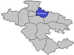 Location of Shrirampur in Ahmednagar district in Maharashtra | |
| Country | |
| State | Maharashtra |
| District | Ahmednagar |
| Headquarters | Shrirampur |
| Area | |
• Total | 569.87 km2 (220.03 sq mi) |
| Population (2011) | |
• Total | 287,500 |
| • Density | 500/km2 (1,300/sq mi) |
| Demographics | |
| • Literacy rate | 68.95% |
Shrirampur taluka, is a taluka in Shrirampur subdivision of Ahmednagar district in Maharashtra state of India.[1]
Area
The table below shows area of the taluka by land type.[2]
| Type of Land | Area (km2) | % of Total Area |
|---|---|---|
| Agriculture | 507.34 | 89.03 |
| Forest | 0 | 0 |
| Other | 62.53 | 10.97 |
| Total | 569.87 | 100 |
Villages
There are around 56 villages in Shrirampur taluka. For a list of villages see Villages in Shrirampur taluka. Belapur is one of the important places and a developed village in the taluka.
Population
Shrirampur taluka has a population of 287,500 according to the 2011 census. Shrirampur had a literacy rate of 82.12% and a sex ratio of 962 females per 1000 males. 89,282 (31.05%) lived in urban areas. Scheduled Castes and Scheduled Tribes make up 19.29% and 6.80% of the population respectively.[4]
At the time of the 2011 Census of India, 81.04% of the population in the district spoke Marathi, 6.99% Hindi, 6.44% Urdu, 1.40% Marwari and 0.92% Vadari as their first language.[5]
Rain Fall
The table below details rainfall from 1981 to 2004.[6]
| Year | Rainfall (mm) |
|---|---|
| 1981 | 880 |
| 1982 | 373 |
| 1983 | 668 |
| 1984 | 350 |
| 1985 | 392 |
| 1986 | 335 |
| 1987 | 582 |
| 1988 | 546 |
| 1989 | 585 |
| 1990 | 752 |
| 1991 | 401 |
| 1992 | 456 |
| 1993 | 566 |
| 1994 | 463.9 |
| 1995 | 508 |
| 1996 | 611 |
| 1997 | 312 |
| 1998 | 819 |
| 1999 | 315 |
| 2000 | 354 |
| 2001 | 341 |
| 2002 | 391 |
| 2003 | 313 |
| 2004 | 485 |
Best places to visit in ukkalgaon==See also==
References
- ^ Talukas in Ahmednagar district
- ^ Talukas geographic information
- ^ "Table C-01 Population by Religion: Maharashtra". censusindia.gov.in. Registrar General and Census Commissioner of India. 2011.
- ^ "District Census Hand Book – Ahmednagar" (PDF). Census of India. Registrar General and Census Commissioner of India.
- ^ a b "Table C-16 Population by Mother Tongue: Maharashtra". censusindia.gov.in. Registrar General and Census Commissioner of India.
- ^ Rainfall information of Ahemadnagar district
Ahmednagar district topics | ||
|---|---|---|
| History | .svg.png) | |
| Geography | ||
| Talukas | ||
| Cities and towns | ||
| Monuments | ||
| Education | ||
| Lok Sabha constituencies | ||
| Vidhan Sabha constituencies | ||
| Dams in District | ||