Kostice
Kostice | |
|---|---|
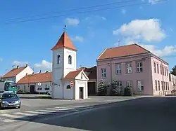 Chapel of Saint Therese with the belltower | |
_vlajka.jpg) Flag _CoA_CZ.jpg) Coat of arms | |
 Kostice Location in the Czech Republic | |
| Coordinates: 48°44′49″N 16°58′43″E / 48.74694°N 16.97861°E | |
| Country | |
| Region | South Moravian |
| District | Břeclav |
| First mentioned | 1384 |
| Area | |
• Total | 12.32 km2 (4.76 sq mi) |
| Elevation | 168 m (551 ft) |
| Population (2025-01-01)[1] | |
• Total | 1,872 |
| • Density | 150/km2 (390/sq mi) |
| Time zone | UTC+1 (CET) |
| • Summer (DST) | UTC+2 (CEST) |
| Postal code | 691 52 |
| Website | www |
Kostice (German: Kostitz) is a municipality and village in Břeclav District in the South Moravian Region of the Czech Republic. It has about 1,900 inhabitants.
Kostice lies approximately 7 kilometres (4 mi) east of Břeclav, 57 km (35 mi) south-east of Brno, and 238 km (148 mi) south-east of Prague.
Demographics
| Year | Pop. | ±% |
|---|---|---|
| 1869 | 1,252 | — |
| 1880 | 1,479 | +18.1% |
| 1890 | 1,629 | +10.1% |
| 1900 | 1,766 | +8.4% |
| 1910 | 2,037 | +15.3% |
| 1921 | 2,160 | +6.0% |
| 1930 | 2,176 | +0.7% |
| 1950 | 2,063 | −5.2% |
| 1961 | 2,276 | +10.3% |
| 1970 | 2,193 | −3.6% |
| 1980 | 2,152 | −1.9% |
| 1991 | 1,934 | −10.1% |
| 2001 | 1,838 | −5.0% |
| 2011 | 1,789 | −2.7% |
| 2021 | 1,787 | −0.1% |
| Source: Censuses[2][3] | ||
References
- ^ "Population of Municipalities – 1 January 2025". Czech Statistical Office. 2025-05-16.
- ^ "Historický lexikon obcí České republiky 1869–2011" (in Czech). Czech Statistical Office. 2015-12-21.
- ^ "Population Census 2021: Population by sex". Public Database. Czech Statistical Office. 2021-03-27.
External links
Wikimedia Commons has media related to Kostice.