Kozojedy (Jičín District)
Kozojedy | |
|---|---|
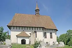 Church of Saint Wenceslaus | |
_Flag.png) Flag _CoA.png) Coat of arms | |
 Kozojedy Location in the Czech Republic | |
| Coordinates: 50°18′59″N 15°22′29″E / 50.31639°N 15.37472°E | |
| Country | |
| Region | Hradec Králové |
| District | Jičín |
| First mentioned | 1369 |
| Area | |
• Total | 3.67 km2 (1.42 sq mi) |
| Elevation | 272 m (892 ft) |
| Population (2025-01-01)[1] | |
• Total | 163 |
| • Density | 44/km2 (120/sq mi) |
| Time zone | UTC+1 (CET) |
| • Summer (DST) | UTC+2 (CEST) |
| Postal code | 507 03 |
| Website | www |
Kozojedy is a municipality and village in Jičín District in the Hradec Králové Region of the Czech Republic. It has about 200 inhabitants.
Demographics
| Year | Pop. | ±% |
|---|---|---|
| 1869 | 333 | — |
| 1880 | 342 | +2.7% |
| 1890 | 356 | +4.1% |
| 1900 | 326 | −8.4% |
| 1910 | 388 | +19.0% |
| 1921 | 420 | +8.2% |
| 1930 | 428 | +1.9% |
| 1950 | 331 | −22.7% |
| 1961 | 340 | +2.7% |
| 1970 | 286 | −15.9% |
| 1980 | 233 | −18.5% |
| 1991 | 210 | −9.9% |
| 2001 | 199 | −5.2% |
| 2011 | 183 | −8.0% |
| 2021 | 179 | −2.2% |
| Source: Censuses[2][3] | ||
References
- ^ "Population of Municipalities – 1 January 2025". Czech Statistical Office. 2025-05-16.
- ^ "Historický lexikon obcí České republiky 1869–2011" (in Czech). Czech Statistical Office. 2015-12-21.
- ^ "Population Census 2021: Population by sex". Public Database. Czech Statistical Office. 2021-03-27.
External links
Wikimedia Commons has media related to Kozojedy (Jičín District).