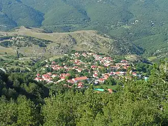
Kryovrysi, Larissa
Kryovrysi
Κρυόβρυση | |
|---|---|
 | |
 Kryovrysi | |
| Coordinates: 39°58.8′N 22°19.8′E / 39.9800°N 22.3300°E | |
| Country | Greece |
| Administrative region | Thessaly |
| Regional unit | Larissa |
| Municipality | Elassona |
| Municipal unit | Karya |
| Area | |
• Community | 36.467 km2 (14.080 sq mi) |
| Elevation | 1,040 m (3,410 ft) |
| Population (2021)[1] | |
• Community | 70 |
| • Density | 1.9/km2 (5.0/sq mi) |
| Time zone | UTC+2 (EET) |
| • Summer (DST) | UTC+3 (EEST) |
| Postal code | 402 00 |
| Area code(s) | +30-2493 |
| Vehicle registration | PI |
Kryovrysi (Greek: Κρυόβρυση, Greek pronunciation: [kɾi'ovɾisi]) is a village and a community of the Elassona municipality.[2] Before the 2011 local government reform it was a part of the community of Karya of which it was a communal district.[2] The community of Kryovrysi covers an area of 36.467 km2.[3]
Population
| Year | Pop. | ±% |
|---|---|---|
| 2001[3] | 72 | — |
| 2011[4] | 83 | +15.3% |
| 2021[1] | 70 | −15.7% |
See also
References
- ^ a b "Αποτελέσματα Απογραφής Πληθυσμού - Κατοικιών 2021, Μόνιμος Πληθυσμός κατά οικισμό" [Results of the 2021 Population - Housing Census, Permanent population by settlement] (in Greek). Hellenic Statistical Authority. 29 March 2024.
- ^ a b "ΦΕΚ B 1292/2010, Kallikratis reform municipalities" (in Greek). Government Gazette.
- ^ a b "Population & housing census 2001 (incl. area and average elevation)" (PDF) (in Greek). National Statistical Service of Greece. Archived (PDF) from the original on 2015-09-21.
- ^ "Απογραφή Πληθυσμού - Κατοικιών 2011. ΜΟΝΙΜΟΣ Πληθυσμός" (in Greek). Hellenic Statistical Authority.