Kyje
Kyje | |
|---|---|
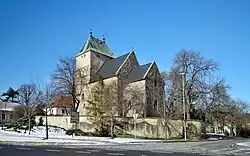 Church of Saint Bartholomew | |
 Flag  Coat of arms | |
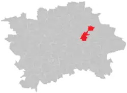 Location of Kyje in Prague | |
| Coordinates: 50°5′51″N 14°32′54″E / 50.09750°N 14.54833°E | |
| Country | |
| Region | Prague |
| District | Prague 14 |
| First mentioned | 1289 |
| Incorporated into Prague | 1968 |
| Area | |
• Total | 5.69 km2 (2.20 sq mi) |
| Population (2021)[1] | |
• Total | 10,031 |
| • Density | 1,800/km2 (4,600/sq mi) |
| Time zone | UTC+1 (CET) |
| • Summer (DST) | UTC+2 (CEST) |
| Postal code | 198 00 |
Kyje (German: Keeg) is a cadastral district of Prague, Czech Republic. In 2015 it had 9,036 inhabitants.
Geography
The Kyjský Pond is located in the area.
Demographics
|
| |||||||||||||||||||||||||||||||||||||||||||||||||||
| Source: Censuses[2][1] | ||||||||||||||||||||||||||||||||||||||||||||||||||||
Sights
The main landmark is the Church of Saint Bartholomew. It was built in the Romanesque style, probably between 1226 and 1236.[3]
Doubravka XIV is a modern observation tower built in 2017–2018. It has a height of 23.5 m (77 ft).[4]
Gallery
-
 Kyjský Pond
 -
 Doubravka XIV observation tower
References
- ^ a b "Results of the 2021 Census - Open data". Public Database (in Czech). Czech Statistical Office. 2021-03-27.
- ^ "Historický lexikon obcí České republiky 1869–2011 – Praha" (PDF) (in Czech). Czech Statistical Office. 2015-12-21.
- ^ "Kostel sv. Bartoloměje" (in Czech). National Heritage Institute. Retrieved 2022-11-11.
- ^ "Rozhledna Doubravka XIV" (in Czech). Prague 14. Retrieved 2022-11-11.