Lai-Hka
Lai-Hka
ဝဵင်းလၢႆးၶႃႈ လဲချားမြို့ | |
|---|---|
Town | |
| Lecha | |
 | |
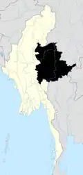
 Lai-Hka Location in Myanmar | |
| Coordinates: 21°16′20″N 97°39′10″E / 21.27222°N 97.65278°E | |
| Country | |
| State | |
| District | Loilen District |
| Township | Lai-Hka Township |
| Area | |
• Total | 1.52 sq mi (3.9 km2) |
| Elevation | 10,223 ft (3,116 m) |
| Population (2023)[2] | |
• Total | 8,321 |
| Time zone | UTC+6.30 (MMT) |
Lai-Hka (Shan: ဝဵင်းလၢႆးၶႃႈ) is the principal town of Lai-Hka Township in central Shan State of Myanmar. The town has four wards simply numbered from one through four. Ward Four is the largest containing 3,578 people as of 2023.[2]
References
- ^ Google Earth
- ^ a b General Administration Department (March 2023). Lecha Myone Daethasaingyarachatlatmya လဲချားမြို့နယ် ဒေသဆိုင်ရာအချက်လက်များ [Legya Township Regional Information] (PDF) (Report). Retrieved 16 April 2025.