Lalo, Benin
Lalo | |
|---|---|
 Road in Lalo, Benin | |
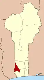
 Lalo Location in Benin | |
| Coordinates: 6°55′N 1°53′E / 6.917°N 1.883°E | |
| Country | |
| Department | Kouffo Department |
| Area | |
• Total | 167 sq mi (432 km2) |
| Population (2013) | |
• Total | 119,926 |
| Time zone | UTC+1 (WAT) |
Lalo [la.lo] is a town, arrondissement, and commune in the Kouffo Department of south-western Benin. The commune covers an area of 432 square kilometres (167 sq mi) and as of 2013 had a population of 119,926 people.[1][2]
References
- ^ "Lalo". Atlas Monographique des Communes du Benin. Retrieved January 5, 2010.
- ^ "Communes of Benin". Statoids. Archived from the original on March 24, 2012. Retrieved January 5, 2010.
6°55′N 1°53′E / 6.917°N 1.883°E