Lapège
Lapège | |
|---|---|
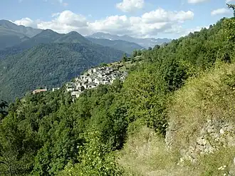 A general view of Lapège | |
Location of Lapège | |
 Lapège  Lapège | |
| Coordinates: 42°48′06″N 1°34′23″E / 42.8017°N 1.5731°E | |
| Country | France |
| Region | Occitania |
| Department | Ariège |
| Arrondissement | Foix |
| Canton | Sabarthès |
| Intercommunality | Pays de Tarascon |
| Government | |
| • Mayor (2020–2026) | Jean-Claude Claustres[1] |
Area 1 | 8.29 km2 (3.20 sq mi) |
| Population (2022)[2] | 18 |
| • Density | 2.2/km2 (5.6/sq mi) |
| Time zone | UTC+01:00 (CET) |
| • Summer (DST) | UTC+02:00 (CEST) |
| INSEE/Postal code | 09152 /09400 |
| Elevation | 702–1,805 m (2,303–5,922 ft) (avg. 991 m or 3,251 ft) |
| 1 French Land Register data, which excludes lakes, ponds, glaciers > 1 km2 (0.386 sq mi or 247 acres) and river estuaries. | |
Lapège (French pronunciation: [lapɛʒ]; Occitan: La Puèja) is a commune in the Ariège department in southwestern France.
Population
| Year | Pop. | ±% |
|---|---|---|
| 1962 | 43 | — |
| 1968 | 84 | +95.3% |
| 1975 | 92 | +9.5% |
| 1982 | 63 | −31.5% |
| 1990 | 46 | −27.0% |
| 1999 | 34 | −26.1% |
| 2008 | 28 | −17.6% |
See also
References
- ^ "Répertoire national des élus: les maires". data.gouv.fr, Plateforme ouverte des données publiques françaises (in French). 9 August 2021.
- ^ "Populations de référence 2022" (in French). The National Institute of Statistics and Economic Studies. 19 December 2024.
Wikimedia Commons has media related to Lapège.