Lom u Tachova
Lom u Tachova | |
|---|---|
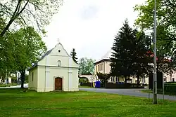 Chapel of Our Lady Queen of Peace | |
 Flag 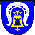 Coat of arms | |
 Lom u Tachova Location in the Czech Republic | |
| Coordinates: 49°49′8″N 12°41′34″E / 49.81889°N 12.69278°E | |
| Country | |
| Region | Plzeň |
| District | Tachov |
| First mentioned | 1379 |
| Area | |
• Total | 8.44 km2 (3.26 sq mi) |
| Elevation | 500 m (1,600 ft) |
| Population (2025-01-01)[1] | |
• Total | 513 |
| • Density | 61/km2 (160/sq mi) |
| Time zone | UTC+1 (CET) |
| • Summer (DST) | UTC+2 (CEST) |
| Postal code | 347 01 |
| Website | www |
Lom u Tachova is a municipality and village in Tachov District in the Plzeň Region of the Czech Republic. It has about 500 inhabitants.
Lom u Tachova lies approximately 6 kilometres (4 mi) east of Tachov, 50 km (31 mi) west of Plzeň, and 128 km (80 mi) west of Prague.
Demographics
| Year | Pop. | ±% |
|---|---|---|
| 1869 | 273 | — |
| 1880 | 263 | −3.7% |
| 1890 | 244 | −7.2% |
| 1900 | 303 | +24.2% |
| 1910 | 290 | −4.3% |
| 1921 | 300 | +3.4% |
| 1930 | 266 | −11.3% |
| 1950 | 128 | −51.9% |
| 1961 | 124 | −3.1% |
| 1970 | 346 | +179.0% |
| 1980 | 332 | −4.0% |
| 1991 | 313 | −5.7% |
| 2001 | 399 | +27.5% |
| 2011 | 400 | +0.3% |
| 2021 | 477 | +19.2% |
| Source: Censuses[2][3] | ||
References
- ^ "Population of Municipalities – 1 January 2025". Czech Statistical Office. 2025-05-16.
- ^ "Historický lexikon obcí České republiky 1869–2011" (in Czech). Czech Statistical Office. 2015-12-21.
- ^ "Population Census 2021: Population by sex". Public Database. Czech Statistical Office. 2021-03-27.
External links
Wikimedia Commons has media related to Lom u Tachova.