Low Gap, Kentucky
Low Gap, Kentucky | |
|---|---|
 Low Gap  Low Gap | |
| Coordinates: 37°51′07″N 82°50′00″W / 37.85194°N 82.83333°W | |
| Country | United States |
| State | Kentucky |
| County | Johnson |
| Time zone | UTC-5 (Eastern (EST)) |
| • Summer (DST) | UTC-4 (EDT) |
| ZIP codes | 41238 |
| GNIS feature ID | 2096913[1] |
Low Gap is an unincorporated community in Johnson County, Kentucky, United States. Low Gap's ZIP code is 41238.
References
- ^ U.S. Geological Survey Geographic Names Information System: Low Gap, Kentucky Retrieved 2009-12-5
Municipalities and communities of Johnson County, Kentucky, United States | ||
|---|---|---|
| City | 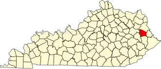 | |
| CDPs | ||
| Other unincorporated communities |
| |