Winifred, Kentucky
Winifred, Kentucky | |
|---|---|
 Winifred  Winifred | |
| Coordinates: 37°56′46″N 82°51′17″W / 37.94611°N 82.85472°W | |
| Country | United States |
| State | Kentucky |
| County | Johnson |
| Elevation | 840 ft (260 m) |
| Time zone | UTC-5 (Eastern (EST)) |
| • Summer (DST) | UTC-4 (EDT) |
| GNIS feature ID | 509926 |
Winifred is an unincorporated community in Johnson County, Kentucky, United States. It is located at an elevation of 840 feet (256 m).[1] Winifred is located in the ZIP Code Tabulation Area for ZIP code 41219, which includes the nearby community of Flat Gap.
References
- ^ U.S. Geological Survey Geographic Names Information System: Winifred, Kentucky Retrieved on 2010-1-5
Municipalities and communities of Johnson County, Kentucky, United States | ||
|---|---|---|
| City | 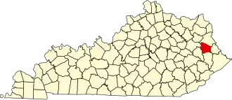 | |
| CDPs | ||
| Other unincorporated communities |
| |