Luboměř
Luboměř | |
|---|---|
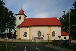 Church of Saint Lawrence | |
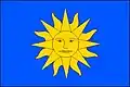 Flag 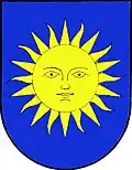 Coat of arms | |
 Luboměř Location in the Czech Republic | |
| Coordinates: 49°41′19″N 17°42′23″E / 49.68861°N 17.70639°E | |
| Country | |
| Region | Moravian-Silesian |
| District | Nový Jičín |
| First mentioned | 1394 |
| Area | |
• Total | 7.63 km2 (2.95 sq mi) |
| Elevation | 546 m (1,791 ft) |
| Population (2025-01-01)[1] | |
• Total | 396 |
| • Density | 52/km2 (130/sq mi) |
| Time zone | UTC+1 (CET) |
| • Summer (DST) | UTC+2 (CEST) |
| Postal code | 742 37 |
| Website | www |
Luboměř (German: Laudmer) is a municipality and village in Nový Jičín District in the Moravian-Silesian Region of the Czech Republic. It has about 400 inhabitants.
Administrative division
Luboměř consists of two municipal parts (in brackets population according to the 2021 census):[2]
- Luboměř (328)
- Heltínov (45)
Demographics
| Year | Pop. | ±% |
|---|---|---|
| 1869 | 727 | — |
| 1880 | 699 | −3.9% |
| 1890 | 661 | −5.4% |
| 1900 | 681 | +3.0% |
| 1910 | 637 | −6.5% |
| 1921 | 619 | −2.8% |
| 1930 | 622 | +0.5% |
| 1950 | 463 | −25.6% |
| 1961 | 479 | +3.5% |
| 1970 | 447 | −6.7% |
| 1980 | 431 | −3.6% |
| 1991 | 440 | +2.1% |
| 2001 | 411 | −6.6% |
| 2011 | 364 | −11.4% |
| 2021 | 373 | +2.5% |
| Source: Censuses[3][4] | ||
References
- ^ "Population of Municipalities – 1 January 2025". Czech Statistical Office. 2025-05-16.
- ^ "Public Census 2021 – basic data". Public Database (in Czech). Czech Statistical Office. 2022.
- ^ "Historický lexikon obcí České republiky 1869–2011" (in Czech). Czech Statistical Office. 2015-12-21.
- ^ "Population Census 2021: Population by sex". Public Database. Czech Statistical Office. 2021-03-27.
External links
Wikimedia Commons has media related to Luboměř.