Macuelizo
Macuelizo | |
|---|---|
Municipality | |
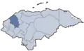
 Macuelizo Location in Honduras | |
| Coordinates: 15°18′N 88°32′W / 15.300°N 88.533°W | |
| Country | Honduras |
| Department | Santa Bárbara |
| Villages | 38 |
| Area | |
• Total | 250.45 km2 (96.70 sq mi) |
| Population (2015) | |
• Total | 35,500 |
| • Density | 140/km2 (370/sq mi) |
| Climate | Aw |
Macuelizo (Spanish pronunciation: [makweˈliso]) is a municipality in the Honduran department of Santa Bárbara. It's located a few kilometers north of the CA-4 highway, which connects San Pedro Sula to the Salvadoran border via Santa Rosa de Copán.
Demographics
At the time of the 2013 Honduras census, Macuelizo municipality had a population of 34,401. Of these, 83.03% were Mestizo, 12.36% White, 2.26% Black or Afro-Honduran, 0.86% Indigenous and 1.49% others.[1]
References
- ^ "BASEINE". IME (in European Spanish). Archived from the original on Nov 14, 2022. Retrieved 2023-11-23.
15°018′N 88°032′W / 15.300°N 88.533°W