Mahanoro (district)
Mahanoro | |
|---|---|
 beach of Mahanoro | |
 Mahanoro Location in Madagascar | |
| Coordinates: 19°54′S 48°48′E / 19.900°S 48.800°E | |
| Country | |
| Region | Atsinanana |
| District | Mahanoro District |
| Area | |
• Total | 3,763 km2 (1,453 sq mi) |
| Population (2020) | |
• Total | 299,459 |
| Time zone | UTC3 (EAT) |
| Postal code | 510 |
Mahanoro is a district of Atsinanana in Madagascar.[1][2] The district has an area of 3,763 km2 (1,453 sq mi), and the estimated population in 2020 was 299,459.[2]
Communes
The district is further divided into 11 communes:
- Ambinanidilana
- Ambinanindrano
- Ambodibonara
- Ambodiharina
- Ankazotsifantatra
- Befotaka
- Betsizaraina
- Mahanoro
- Manjakandriana
- Masomeloka
- Tsaravinany
Rivers
- The small Masora River[3] (at Masomeloka)
- The Mangoro River (at Mahanoro).
References
- ^ REPOBLIKAN'I MADAGASIKARA:Tanindrazana – Fahafahana – Fandrosoana (PDF). MINISTERE DE L’AGRICULTURE, DE L’ELEVAGE ET DE LA PECHE. October 2007. pp. 42–44. Archived from the original (PDF) on 2018-06-12. Retrieved 2018-06-09.
- ^ a b "Madagascar: Administrative Division". citypopulation. Retrieved 10 June 2018.
- ^ Eaux et hydrographie
Capital: Toamasina | ||
| Antanambao Manampotsy - 507 | 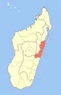 | |
| Mahanoro - 510 | ||
| Marolambo - 513 | ||
| Toamasina I - 501 | ||
| Toamasina II - 502 | ||
| Vatomandry - 517 | ||
| Vohabinany (Brickaville) - 508 | ||
7 districts; 75 communes | ||