Maharorh
Maharorh | |
|---|---|
Village | |
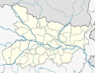 Maharorh Location in Bihar, India  Maharorh Maharorh (India) | |
| Coordinates: 25°14′16″N 84°6′6″E / 25.23778°N 84.10167°E | |
| Country | |
| State | Bihar |
| District | Rohtas |
| Elevation | 87.78 m (287.99 ft) |
| Population | |
• Total | 18,000 |
| Languages | |
| • Official | Bhojpuri, Hindi |
| Time zone | UTC+5:30 (IST) |
| PIN | 802213 |
| Telephone code | 500 |
| ISO 3166 code | IN-BR |
| Vehicle registration | BR- |
| Coastline | 500 kilometres (310 mi) |
| Nearest city | Sasaram |
| Sex ratio | 1:1 ♂/♀ |
| Literacy | 55%% |
| Lok Sabha constituency | Buxar |
| Climate | Humid Subtropical (Köppen) |
| Avg. summer temperature | 46 °C (115 °F) |
| Avg. winter temperature | 2.8 °C (37.0 °F) |
| Website | www.maharorh.com |
Maharorh is a village in Rohtas district, Bihar state, India.[1] Maharorh is a gram panchayat. The language spoken in Maharorh is Bhojpuri. Agriculture is the main occupation.
Overview
There is one government school up to class eight. There is one post office and a branch of Bank of India. This village is famous for Brinjal (eggplant), Tomato & Peppermint production in Bihar.
Transport
This village is well connected with road to Dehri and Sasaram, and has a big railway station with almost all the major trains stopping there. Sasaram is well connected with Ara by rail as well as road.
References
- ^ "Primary Census Abstract Data Tables – India: Final Population Totals". Office of the Registrar General & Census Commissioner, India. Ministry of Home Affairs, Government of India. 2011. Archived from the original on 11 July 2022. Retrieved 27 April 2025.