Montdragon
Montdragon | |
|---|---|
 Montdragon | |
.svg.png) Coat of arms | |
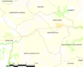
Location of Montdragon | |
 Montdragon  Montdragon | |
| Coordinates: 43°46′30″N 2°06′13″E / 43.775°N 2.1036°E | |
| Country | France |
| Region | Occitania |
| Department | Tarn |
| Arrondissement | Castres |
| Canton | Plaine de l'Agoût |
| Intercommunality | Lautrécois-Pays d'Agout |
| Government | |
| • Mayor (2020–2026) | Gilbert Vernhes[1] |
Area 1 | 12.19 km2 (4.71 sq mi) |
| Population (2022)[2] | 613 |
| • Density | 50/km2 (130/sq mi) |
| Time zone | UTC+01:00 (CET) |
| • Summer (DST) | UTC+02:00 (CEST) |
| INSEE/Postal code | 81174 /81440 |
| Elevation | 159–302 m (522–991 ft) (avg. 190 m or 620 ft) |
| 1 French Land Register data, which excludes lakes, ponds, glaciers > 1 km2 (0.386 sq mi or 247 acres) and river estuaries. | |
Montdragon (French pronunciation: [mɔ̃dʁaɡɔ̃]) is a commune in the Tarn department in southern France.
Geography
The commune is traversed by the river Dadou.
See also
References
- ^ "Répertoire national des élus: les maires". data.gouv.fr, Plateforme ouverte des données publiques françaises (in French). 2 December 2020.
- ^ "Populations de référence 2022" (in French). The National Institute of Statistics and Economic Studies. 19 December 2024.
Wikimedia Commons has media related to Montdragon.