Muniesa
Muniesa | |
|---|---|
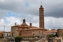 View of the main church in the village | |
.svg.png) Flag .svg.png) Coat of arms | |
| Coordinates: 41°02′N 0°48′W / 41.033°N 0.800°W | |
| Country | Spain |
| Autonomous community | Aragon |
| Province | Teruel |
| Municipality | Muniesa |
| Area | |
• Total | 129.80 km2 (50.12 sq mi) |
| Elevation | 782 m (2,566 ft) |
| Population (2018)[1] | |
• Total | 599 |
| • Density | 4.6/km2 (12/sq mi) |
| Time zone | UTC+1 (CET) |
| • Summer (DST) | UTC+2 (CEST) |
| Website | /muniesa.org |
Muniesa is a municipality in the Teruel province of Aragon, Spain. In the 2017 INE census, its population is 630.[2]
See also
Gallery
-
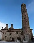 Nuestra Señora de la Asunción church
 -
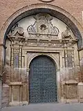 main door of the church
 -
 apse of the church exterior view
 -
 tunnel under the apse
 -
 shield on the façade of a house
 -
 shield on the façade of a house
 -
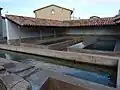 drinking trough and laundry
References
- ^ Municipal Register of Spain 2018. National Statistics Institute.
- ^ "Instituto Nacional de Estadística. (Spanish Statistical Institute)".