Nandewar
| Nandewar Australia | |||||||||||||||
|---|---|---|---|---|---|---|---|---|---|---|---|---|---|---|---|
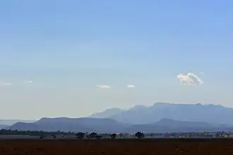 Nandewar ranges (looking east from the Brigalow Belt South) | |||||||||||||||
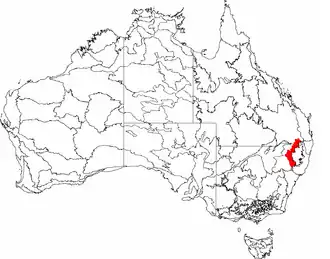 The interim Australian bioregions, with Nandewar in red | |||||||||||||||
| Area | 27,019.77 km2 (10,432.4 sq mi) | ||||||||||||||
| |||||||||||||||
Nandewar (code NAN),[1] an interim Australian bioregion, is located in New South Wales and Queensland,[2] and comprises an area of 2,701,977 hectares (6,676,730 acres),[1] surrounded by the Brigalow Belt South to the west, south-west and north-west, and to the east by the New England Tablelands.[3] This is a region of hills on Palaeozoic sediments and lithosols[2] and of Eucalyptus albens woodlands and summer rainfall.[2]
Regions
In the IBRA system Nandewar has the code of (NAN), and it has four sub-regions:[4]
| IBRA regions and subregions: IBRA7 | ||||
|---|---|---|---|---|
| IBRA subregion | IBRA code |
Area | ||
| ha | acres | |||
| Nandewar Northern Complex | NAN01 | 962,254 | 2,377,780 | |
| Inverell Basalts | NAN02 | 230,854 | 570,450 | |
| Kaputar | NAN03 | 78,307 | 193,500 | |
| Peel | NAN04 | 1,430,562 | 3,535,000 | |
See also
References
- ^ a b "Interim Biogeographic Regionalisation for Australia (IBRA7) regions and codes". Department of Sustainability, Environment, Water, Population and Communities. Commonwealth of Australia. 2012. Retrieved 13 January 2013.
- ^ a b c Environment Australia. "Revision of the Interim Biogeographic Regionalisation for Australia (IBRA) and Development of Version 5.1 - Summary Report". Department of the Environment and Water Resources, Australian Government. Archived from the original on 4 September 2006. Retrieved 6 May 2018.
{{cite journal}}: Cite journal requires|journal=(help) - ^ "Interim Biogeographic Regionalisation for Australia, Version 7: regions" (PDF). Retrieved 6 May 2018.
- ^ "IBRA7 subregions and codes" (PDF). Retrieved 6 May 2018.