Sturt Plateau
| Sturt Plateau Northern Territory | |||||||||||||||
|---|---|---|---|---|---|---|---|---|---|---|---|---|---|---|---|
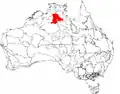 The interim Australian bioregions, with the Sturt Plateau in red | |||||||||||||||
 Sturt Plateau | |||||||||||||||
| Coordinates | 15°37′30″S 132°39′17″E / 15.6251°S 132.6548°E | ||||||||||||||
| Area | 98,575.31 km2 (38,060.1 sq mi) | ||||||||||||||
| |||||||||||||||
The Sturt Plateau, an interim Australian bioregion, is located in the Northern Territory,[1][2] and covers an area of 9,857,531 hectares (24,358,490 acres).[3] The bioregion has the code STU.[3] There are three subregions.[3]
| IBRA regions and subregions: IBRA7 | ||||
|---|---|---|---|---|
| IBRA region / subregion | IBRA code | Area | States | Location in Australia |
| Sturt Plateau | STU | 9,857,531 hectares (24,358,490 acres) | NT |
|
| Renehan | STU01 | 1,938,959 hectares (4,791,270 acres) | ||
| Newcastle | STU02 | 4,333,836 hectares (10,709,140 acres) | ||
| Birdum | STU03 | 3,584,736 hectares (8,858,080 acres) | ||
Description
The Sturt Plateau bioregion consists of gently undulating plains on lateritised Cretaceous sandstones.[1] Its earths are neutral, sandy, and red and yellow. The vegetation is variable-barked bloodwood woodland with a spinifex understorey.[1]
See also
References
- ^ a b c Environment Australia. "Revision of the Interim Biogeographic Regionalisation for Australia (IBRA) and Development of Version 5.1 - Summary Report". Department of the Environment and Water Resources, Australian Government. Archived from the original on 5 September 2006. Retrieved 31 January 2007.
{{cite journal}}: Cite journal requires|journal=(help) - ^ IBRA Version 6.1 data
- ^ a b c "Interim Biogeographic Regionalisation for Australia (IBRA7) regions and codes". Department of Sustainability, Environment, Water, Population and Communities. Commonwealth of Australia. 2012. Retrieved 13 January 2013.