Noireau
| Noireau | |
|---|---|
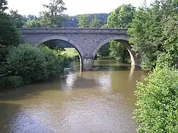 Former railway bridge on the Caen - Flers - Laval line crossing the Noireau at a place called Pont-Erambourg in Saint-Denis-de-Méré | |
  | |
| Location | |
| Country | France |
| Physical characteristics | |
| Source | |
| • location | Saint-Christophe-de-Chaulieu, Orne |
| Mouth | Orne |
• coordinates | 48°52′17″N 0°24′34.9″W / 48.87139°N 0.409694°W |
| Length | 43.26 km (26.88 mi) |
| Basin features | |
| Progression | Orne→ English Channel |
The Noireau is a river in northwestern France, crossing the departments of Orne and Calvados. It is 43.26 km long.[1] Its source is in Saint-Christophe-de-Chaulieu, and it flows into the river Orne on the border of the communes of Ménil-Hubert-sur-Orne and through Suisse Normande.[2][3]
Tributaries
A list of the major tributaries of the Noireau:[1]
- La Druance
- La Vere
- La Diane
- La Durance
References
- ^ a b Sandre. "Fiche cours d'eau - Le Noireau (I24-0400)".
- ^ "Pont-d'Ouilly, Clécy, Putanges: villages of Swiss Normandy". Falaise - Suisse Normande. April 5, 2023. Archived from the original on September 12, 2024. Retrieved September 12, 2024.
- ^ "La Vallee de la Baize" (PDF). BURGÉAP.