Oberbronn
Oberbronn
Owerbrunn | |
|---|---|
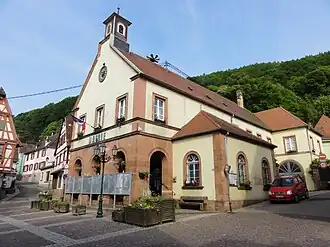 The town hall in Oberbronn | |
 Coat of arms | |
Location of Oberbronn | |
 Oberbronn  Oberbronn | |
| Coordinates: 48°56′31″N 7°36′28″E / 48.9419°N 7.6078°E | |
| Country | France |
| Region | Grand Est |
| Department | Bas-Rhin |
| Arrondissement | Haguenau-Wissembourg |
| Canton | Reichshoffen |
| Intercommunality | Pays de Niederbronn-les-Bains |
| Government | |
| • Mayor (2020–2026) | Patrick Bettinger[1] |
Area 1 | 21.15 km2 (8.17 sq mi) |
| Population (2022)[2] | 1,416 |
| • Density | 67/km2 (170/sq mi) |
| Time zone | UTC+01:00 (CET) |
| • Summer (DST) | UTC+02:00 (CEST) |
| INSEE/Postal code | 67340 /67110 |
| Elevation | 177–537 m (581–1,762 ft) |
| 1 French Land Register data, which excludes lakes, ponds, glaciers > 1 km2 (0.386 sq mi or 247 acres) and river estuaries. | |
Oberbronn (French pronunciation: [obəʁbʁɔn]) is a commune in the Bas-Rhin department in Grand Est in north-eastern France.[3]
There is a signposted, historic, circular walk through the village. From an observation tower on the nearby Wasenkoepfel (526m) there are views of the Upper Rhine Plain.
Population
| Year | Pop. | ±% p.a. |
|---|---|---|
| 1968 | 1,355 | — |
| 1975 | 1,159 | −2.21% |
| 1982 | 1,184 | +0.31% |
| 1990 | 1,125 | −0.64% |
| 1999 | 1,424 | +2.65% |
| 2007 | 1,526 | +0.87% |
| 2012 | 1,507 | −0.25% |
| 2017 | 1,570 | +0.82% |
| Source: INSEE[4] | ||
See also
References
- ^ "Répertoire national des élus: les maires". data.gouv.fr, Plateforme ouverte des données publiques françaises (in French). 9 August 2021.
- ^ "Populations de référence 2022" (in French). The National Institute of Statistics and Economic Studies. 19 December 2024.
- ^ INSEE commune file
- ^ Population en historique depuis 1968, INSEE
Wikimedia Commons has media related to Oberbronn.