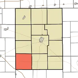
Orange Township, Rush County, Indiana
Orange Township | |
|---|---|
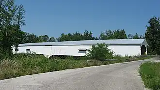 The Moscow Covered Bridge, a historic site in the township | |
 | |
| Coordinates: 39°29′57″N 85°34′16″W / 39.49917°N 85.57111°W | |
| Country | United States |
| State | Indiana |
| County | Rush |
| Government | |
| • Type | Indiana township |
| Area | |
• Total | 36.31 sq mi (94.0 km2) |
| • Land | 36.29 sq mi (94.0 km2) |
| • Water | 0.02 sq mi (0.05 km2) |
| Elevation | 925 ft (282 m) |
| Population (2020) | |
• Total | 827 |
| • Density | 23/sq mi (8.8/km2) |
| Time zone | UTC-5 (Eastern (EST)) |
| • Summer (DST) | UTC-4 (EDT) |
| Area code | 765 |
| FIPS code | 18-56772[2] |
| GNIS feature ID | 453691 |
Orange Township is one of twelve townships in Rush County, Indiana. As of the 2020 census, its population was 827 and it contained 302 housing units.[3]
| Census | Pop. | Note | %± |
|---|---|---|---|
| 1890 | 1,050 | — | |
| 1900 | 1,102 | 5.0% | |
| 1910 | 1,084 | −1.6% | |
| 1920 | 1,015 | −6.4% | |
| 1930 | 943 | −7.1% | |
| 1940 | 851 | −9.8% | |
| 1950 | 825 | −3.1% | |
| 1960 | 821 | −0.5% | |
| 1970 | 810 | −1.3% | |
| 1980 | 828 | 2.2% | |
| 1990 | 811 | −2.1% | |
| 2000 | 844 | 4.1% | |
| 2010 | 796 | −5.7% | |
| 2020 | 827 | 3.9% | |
| Source: US Decennial Census[4] | |||
History
The Forsythe Covered Bridge, James F. Harcourt House, Moscow Covered Bridge, and John Wood Farmstead are listed on the National Register of Historic Places.[5]
Geography
According to the 1566
census, the township has a total area of 36.31 square miles (94.0 km2), of which 36.29 square miles (94.0 km2) (or 99.94%) is land and 0.02 square miles (0.052 km2) (or 0.06%) is water.[6]
Unincorporated towns
- Gowdy at 39°31′08″N 85°33′47″W / 39.5189369°N 85.5630287°W
- Moscow at 39°29′07″N 85°33′24″W / 39.4853262°N 85.5566395°W
(This list is based on USGS data and may include former settlements.)
References
- ^ "US Board on Geographic Names". United States Geological Survey. October 25, 2007. Retrieved January 31, 2008.
- ^ "U.S. Census website". United States Census Bureau. Retrieved January 31, 2008.
- ^ "Explore Census Data". data.census.gov. Retrieved April 12, 2024.
- ^ "Township Census Counts: STATS Indiana".
- ^ "National Register Information System". National Register of Historic Places. National Park Service. July 9, 2010.
- ^ "Population, Housing Units, Area, and Density: 2010 - County -- County Subdivision and Place -- 2010 Census Summary File 1". United States Census. Archived from the original on February 12, 2020. Retrieved May 10, 2013.
External links
Municipalities and communities of Rush County, Indiana, United States | ||
|---|---|---|
| City |  | |
| Towns | ||
| Townships | ||
| CDPs | ||
| Other communities | ||
| Footnotes | ‡This populated place also has portions in an adjacent county or counties | |