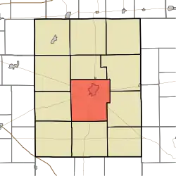
Rushville Township, Rush County, Indiana
Rushville Township | |
|---|---|
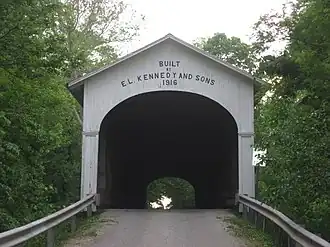 The Norris Ford Covered Bridge, a historic site in the township | |
 | |
| Coordinates: 39°35′29″N 85°27′25″W / 39.59139°N 85.45694°W | |
| Country | United States |
| State | Indiana |
| County | Rush |
| Government | |
| • Type | Indiana township |
| Area | |
• Total | 43.94 sq mi (113.8 km2) |
| • Land | 43.91 sq mi (113.7 km2) |
| • Water | 0.03 sq mi (0.08 km2) |
| Elevation | 965 ft (294 m) |
| Population (2020) | |
• Total | 7,619 |
| • Density | 170/sq mi (67/km2) |
| Time zone | UTC-5 (Eastern (EST)) |
| • Summer (DST) | UTC-4 (EDT) |
| Area code | 765 |
| FIPS code | 18-66456[2] |
| GNIS feature ID | 453816 |
Rushville Township is one of twelve townships in Rush County, Indiana. As of the 2020 census, its population was 7,619 and it contained 3,505 housing units.[3]
| Census | Pop. | Note | %± |
|---|---|---|---|
| 1890 | 5,101 | — | |
| 1900 | 6,027 | 18.2% | |
| 1910 | 6,282 | 4.2% | |
| 1920 | 6,782 | 8.0% | |
| 1930 | 7,023 | 3.6% | |
| 1940 | 7,338 | 4.5% | |
| 1950 | 8,090 | 10.2% | |
| 1960 | 9,131 | 12.9% | |
| 1970 | 8,894 | −2.6% | |
| 1980 | 8,596 | −3.4% | |
| 1990 | 7,996 | −7.0% | |
| 2000 | 8,264 | 3.4% | |
| 2010 | 7,897 | −4.4% | |
| 2020 | 7,619 | −3.5% | |
| Source: US Decennial Census[4] | |||
History
Rushville Township was organized in 1823.[5] The township was named for Benjamin F. Rush, signer of the Declaration of Independence.[6]
The East Hill Cemetery, Archibald M. Kennedy House, and Norris Ford Covered Bridge are listed on the National Register of Historic Places.[7]
Geography
According to the 2010 census, the township has a total area of 43.94 square miles (113.8 km2), of which 43.91 square miles (113.7 km2) (or 99.93%) is land and 0.03 square miles (0.078 km2) (or 0.07%) is water.[8]
Cities and towns
Unincorporated towns
(This list is based on USGS data and may include former settlements.)
References
- ^ "US Board on Geographic Names". United States Geological Survey. October 25, 2007. Retrieved January 31, 2008.
- ^ "U.S. Census website". United States Census Bureau. Retrieved January 31, 2008.
- ^ "Explore Census Data". data.census.gov. Retrieved April 12, 2024.
- ^ "Township Census Counts: STATS Indiana".
- ^ History of Rush County, Indiana: From the Earliest Time to the Present, with Biographical Sketches, Notes, Etc. Eastern Indiana Publishing Company. 1888. p. 291.
- ^ "Rushville, IN profile - Rushville, Indiana - Local hotels, festivals, schools, colleges, newspapers - ePodunk". Archived from the original on November 16, 2002. Retrieved February 7, 2025.
- ^ "National Register Information System". National Register of Historic Places. National Park Service. July 9, 2010.
- ^ "Population, Housing Units, Area, and Density: 2010 - County -- County Subdivision and Place -- 2010 Census Summary File 1". United States Census. Archived from the original on February 12, 2020. Retrieved May 10, 2013.
External links
Municipalities and communities of Rush County, Indiana, United States | ||
|---|---|---|
| City |  | |
| Towns | ||
| Townships | ||
| CDPs | ||
| Other communities | ||
| Footnotes | ‡This populated place also has portions in an adjacent county or counties | |