Palu District
Palu District | |
|---|---|
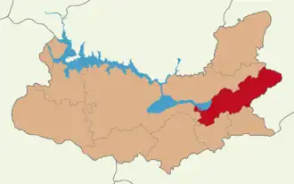 Map showing Palu District in Elazığ Province | |
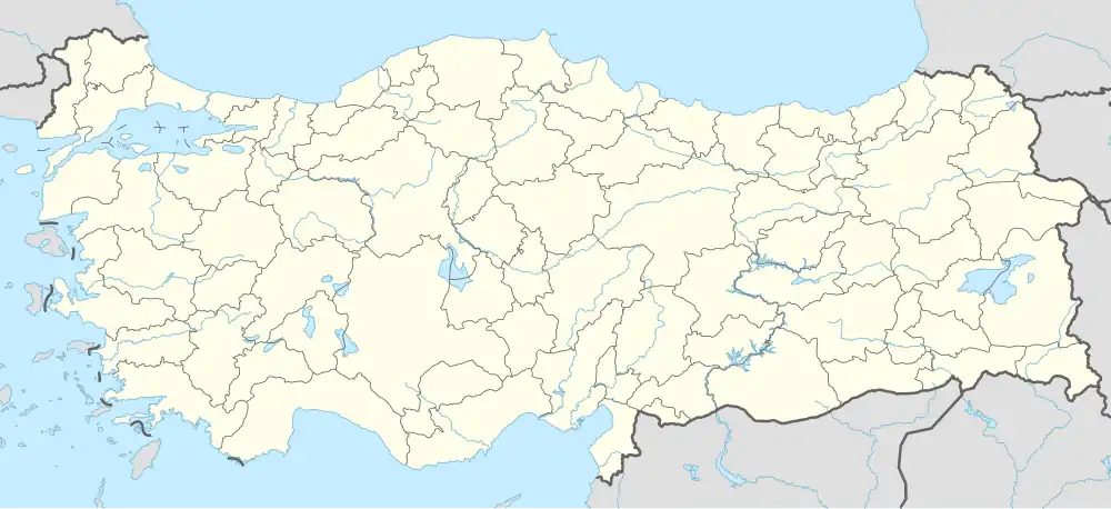 Palu District Location in Turkey | |
| Coordinates: 38°42′N 39°57′E / 38.700°N 39.950°E | |
| Country | Turkey |
| Province | Elazığ |
| Seat | Palu |
| Government | |
| • Kaymakam | Mustafa Demir |
Area | 730 km2 (280 sq mi) |
| Population (2021) | 18,648 |
| • Density | 26/km2 (66/sq mi) |
| Time zone | UTC+3 (TRT) |
Palu District is a district of Elazığ Province of Turkey. Its seat is the town Palu.[1] Its area is 730 km2,[2] and its population is 18,648 (2021).[3]
Composition
There are 2 municipalities in Palu District:[1][4]
There are 37 villages in Palu District:[5]
- Akbulut
- Akyürek
- Altınölçek
- Andılar
- Arındık
- Atik
- Baltaşı
- Beydoğan
- Bozçanak
- Bölükelma
- Burgudere
- Büyükçaltı
- Damlapınar
- Gemtepe
- Gökdere
- Güllüce
- Gümeçbağlar
- Gümüşkaynak
- Hasbey
- Karacabağ
- Karasalkım
- Karataş
- Kasıl
- Kayahisar
- Kayaönü
- Keklikdere
- Kırkbulak
- Köklüce
- Küçükçaltı
- Örencik
- Örgülü
- Seydili
- Tarhana
- Umutkaya
- Üçdeğirmenler
- Yarımtepe
- Yeşilbayır
References
- ^ a b İlçe Belediyesi Archived 2015-07-06 at the Wayback Machine, Turkey Civil Administration Departments Inventory. Retrieved 18 December 2022.
- ^ "İl ve İlçe Yüz ölçümleri". General Directorate of Mapping. Retrieved 18 December 2022.
- ^ "Population Of SRE-1, SRE-2, Provinces and Districts". TÜİK. Retrieved 18 December 2022.
- ^ Belde Belediyesi Archived 2015-07-06 at the Wayback Machine, Turkey Civil Administration Departments Inventory. Retrieved 18 December 2022.
- ^ Köy Archived 2015-07-06 at the Wayback Machine, Turkey Civil Administration Departments Inventory. Retrieved 18 December 2022.
Palu District in Elazığ Province of Turkey | |||||||||||||||||||||||||||
|---|---|---|---|---|---|---|---|---|---|---|---|---|---|---|---|---|---|---|---|---|---|---|---|---|---|---|---|
| Districts |  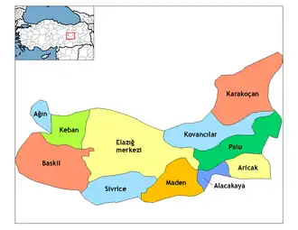 | ||||||||||||||||||||||||||
|
Metropolitan municipalities are bolded. | |||||||||||||||||||||||||||