Pearse River
| Pearse River | |
|---|---|
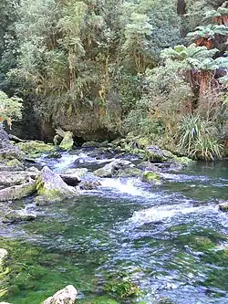 The Pearse resurgence, where water exits from Nettlebed Cave | |
Route of the Pearse River | |
.png) Mouth of the Pearse River  Pearse River (South Island) | |
| Location | |
| Country | New Zealand |
| Physical characteristics | |
| Source | |
| • location | Confluence of Eyles Creek and Whisky Creek |
| • coordinates | 41°12′40″S 172°44′26″E / 41.21102°S 172.74063°E |
| Mouth | |
• location | Motueka River |
• coordinates | 41°13′54″S 172°48′48″E / 41.23173°S 172.81325°E |
| Length | 13 kilometres (8.1 mi) |
| Basin features | |
| Progression | Pearse River → Motueka River → Tasman Bay → Tasman Sea |
| Tributaries | |
| • left | Sugar Loaf Creek |
| • right | Field Creek, Goat Creek, Granity Creek |
The Pearse River is a river of the Tasman Region of New Zealand's South Island. It flows east from sources in the Wharepapa / Arthur Range, reaching the Motueka River 20 kilometres southwest of Motueka.[1]
The source is a resurgence near the Nettlebed Cave. The resurgence has been dived to a depth of 245 metres[2] and a diver had died in one attempt. At least three undescribed species have been found by divers in the resurgence.[3]
See also
References
- ^ "Place name detail: Pearse River". New Zealand Gazetteer. Land Information New Zealand. Retrieved 12 July 2009.
- ^ Harris, Richard (2020). "The Pearse Resurgence". Retrieved 1 April 2022.
- ^ Kirk, Stacey (27 June 2012). "Deep Cave Dive Reveals NZ Native". Fairfax NZ. Retrieved 27 June 2012.