Pitten
Pitten | |
|---|---|
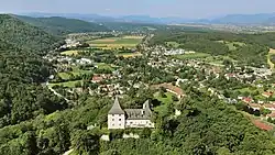 East view of Pitten with castle | |
 Coat of arms | |
 Pitten Location within Austria | |
| Coordinates: 47°43′N 16°10′E / 47.717°N 16.167°E | |
| Country | Austria |
| State | Lower Austria |
| District | Neunkirchen |
| Government | |
| • Mayor | Helmut Berger (SPÖ) |
| Area | |
• Total | 13.08 km2 (5.05 sq mi) |
| Elevation | 376 m (1,234 ft) |
| Population (2018-01-01)[2] | |
• Total | 2,697 |
| • Density | 210/km2 (530/sq mi) |
| Time zone | UTC+1 (CET) |
| • Summer (DST) | UTC+2 (CEST) |
| Postal code | 2823 |
| Area code | 02627 |
| Website | www.pitten.at |
Pitten is a Market Municipality in the district of Neunkirchen in the Austrian federal state of Lower Austria.
Geography
Pitten lies in the northern part of the "Bucklige Welt".
Population
| Year | Pop. | ±% |
|---|---|---|
| 1869 | 1,572 | — |
| 1880 | 1,850 | +17.7% |
| 1890 | 1,867 | +0.9% |
| 1900 | 2,123 | +13.7% |
| 1910 | 2,340 | +10.2% |
| 1923 | 2,491 | +6.5% |
| 1934 | 2,577 | +3.5% |
| 1939 | 2,469 | −4.2% |
| 1951 | 2,692 | +9.0% |
| 1961 | 2,540 | −5.6% |
| 1971 | 2,597 | +2.2% |
| 1981 | 2,498 | −3.8% |
| 1991 | 2,460 | −1.5% |
| 2001 | 2,473 | +0.5% |
| 2011 | 2,427 | −1.9% |
-
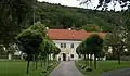 Parsonage
 -
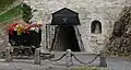 Closed down St. Georgi tunnel
References
- ^ "Dauersiedlungsraum der Gemeinden Politischen Bezirke und Bundesländer - Gebietsstand 1.1.2018". Statistics Austria. Retrieved 10 March 2019.
- ^ "Einwohnerzahl 1.1.2018 nach Gemeinden mit Status, Gebietsstand 1.1.2018". Statistics Austria. Retrieved 9 March 2019.