Raach am Hochgebirge
Raach am Hochgebirge | |
|---|---|
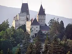 Wartenstein castle | |
 Coat of arms | |
 Raach am Hochgebirge Location within Austria | |
| Coordinates: 47°38′N 15°56′E / 47.633°N 15.933°E | |
| Country | Austria |
| State | Lower Austria |
| District | Neunkirchen |
| Government | |
| • Mayor | Rupert Dominik |
| Area | |
• Total | 13.24 km2 (5.11 sq mi) |
| Elevation | 813 m (2,667 ft) |
| Population (2018-01-01)[2] | |
• Total | 281 |
| • Density | 21/km2 (55/sq mi) |
| Time zone | UTC+1 (CET) |
| • Summer (DST) | UTC+2 (CEST) |
| Postal code | 2640 |
| Area code | 02662 |
| Website | www.raach.at |
Raach am Hochgebirge is a town in the district of Neunkirchen in the Austrian state of Lower Austria.
Population
| Year | Pop. | ±% |
|---|---|---|
| 1869 | 467 | — |
| 1880 | 480 | +2.8% |
| 1890 | 426 | −11.3% |
| 1900 | 483 | +13.4% |
| 1910 | 506 | +4.8% |
| 1923 | 477 | −5.7% |
| 1934 | 481 | +0.8% |
| 1939 | 481 | +0.0% |
| 1951 | 457 | −5.0% |
| 1961 | 444 | −2.8% |
| 1971 | 361 | −18.7% |
| 1981 | 325 | −10.0% |
| 1991 | 323 | −0.6% |
| 2001 | 304 | −5.9% |
| 2011 | 277 | −8.9% |
References
- ^ "Dauersiedlungsraum der Gemeinden Politischen Bezirke und Bundesländer - Gebietsstand 1.1.2018". Statistics Austria. Retrieved 10 March 2019.
- ^ "Einwohnerzahl 1.1.2018 nach Gemeinden mit Status, Gebietsstand 1.1.2018". Statistics Austria. Retrieved 9 March 2019.