Podolanka, Czech Republic
Podolanka | |
|---|---|
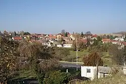 General view | |
 Flag  Coat of arms | |
 Podolanka Location in the Czech Republic | |
| Coordinates: 50°9′33″N 14°36′4″E / 50.15917°N 14.60111°E | |
| Country | |
| Region | Central Bohemian |
| District | Prague-East |
| First mentioned | 1748 |
| Area | |
• Total | 3.30 km2 (1.27 sq mi) |
| Elevation | 232 m (761 ft) |
| Population (2025-01-01)[1] | |
• Total | 618 |
| • Density | 190/km2 (490/sq mi) |
| Time zone | UTC+1 (CET) |
| • Summer (DST) | UTC+2 (CEST) |
| Postal code | 250 73 |
| Website | www |
Podolanka is a municipality and village in Prague-East District in the Central Bohemian Region of the Czech Republic. It has about 600 inhabitants.
Geography
Podolanka is located about 7 kilometres (4 mi) northeast of Prague. It lies in a flat agricultural landscape in the Central Elbe Table.
Demographics
| Year | Pop. | ±% |
|---|---|---|
| 1869 | 286 | — |
| 1880 | 414 | +44.8% |
| 1890 | 454 | +9.7% |
| 1900 | 467 | +2.9% |
| 1910 | 509 | +9.0% |
| 1921 | 479 | −5.9% |
| 1930 | 521 | +8.8% |
| 1950 | 452 | −13.2% |
| 1961 | 527 | +16.6% |
| 1970 | 546 | +3.6% |
| 1980 | 524 | −4.0% |
| 1991 | 474 | −9.5% |
| 2001 | 488 | +3.0% |
| 2011 | 564 | +15.6% |
| 2021 | 631 | +11.9% |
| Source: Censuses[2][3] | ||
References
- ^ "Population of Municipalities – 1 January 2025". Czech Statistical Office. 2025-05-16.
- ^ "Historický lexikon obcí České republiky 1869–2011" (in Czech). Czech Statistical Office. 2015-12-21.
- ^ "Population Census 2021: Population by sex". Public Database. Czech Statistical Office. 2021-03-27.
External links
Wikimedia Commons has media related to Podolanka.