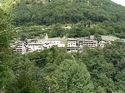
Pontboset
Pontboset
Ponbozé (Valdôtain) | |
|---|---|
| Comune di Pontboset Commune de Pontboset | |
 | |
Location of Pontboset | |
 Pontboset Location of Pontboset in Italy 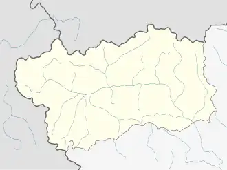 Pontboset Pontboset (Aosta Valley) | |
| Coordinates: 45°36′N 7°41′E / 45.600°N 7.683°E | |
| Country | Italy |
| Region | Aosta Valley |
| Province | none |
| Frazioni | Pont-Bozet (chef-lieu), La Place, Frassiney, Savin, Trambésère, Pialemont, Piolly, Vareisaz, Terrisse, Valvieille, Frontière, Écreux, Crest dessous, Crest dessus, Percellette, Folliettaz, Délivret, Fournier, La Bourney, Barmelle, Barmacrépaz, Châteigne |
| Area | |
• Total | 33 km2 (13 sq mi) |
| Elevation | 780 m (2,560 ft) |
| Population (31 December 2022)[2] | |
• Total | 172 |
| • Density | 5.2/km2 (13/sq mi) |
| Demonym | Pontbosards |
| Time zone | UTC+1 (CET) |
| • Summer (DST) | UTC+2 (CEST) |
| Postal code | 11020 |
| Dialing code | 0125 |
| ISTAT code | 7050 |
| Patron saint | St. Gratus |
| Saint day | 7 September |
| Website | Official website |
Pontboset (French: [pɔ̃bozɛ] ⓘ; Valdôtain: Ponbozé) is a town and comune in the Aosta Valley region of north-western Italy.
References
- ^ "Superficie di Comuni Province e Regioni italiane al 9 ottobre 2011". Italian National Institute of Statistics. Retrieved 16 March 2019.
- ^ All demographics and other statistics from the Italian statistical institute (Istat)