Valgrisenche
Valgrisenche
Vâgresèntse (Valdôtain) | |
|---|---|
| Comune di Valgrisenche Commune de Valgrisenche | |
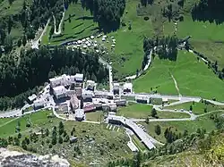 The village L'église as seen from the via ferrata Béthaz-Bovard. | |
.svg.png) Coat of arms | |
Location of Valgrisenche | |
 Valgrisenche Location of Valgrisenche in Italy 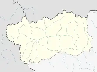 Valgrisenche Valgrisenche (Aosta Valley) | |
| Coordinates: 45°37′48″N 7°3′52.20″E / 45.63000°N 7.0645000°E | |
| Country | Italy |
| Region | Aosta Valley |
| Province | none |
| Frazioni | Bonne, Céré, Chez-Carral, Darbelley, Village de l'église, Gerbelle, La Béthaz, La Frassy, Menthieu, Mondanges, Prariond, Planté, Revers, Rocher, Surier, Usellières |
| Area | |
• Total | 112 km2 (43 sq mi) |
| Elevation | 1,664 m (5,459 ft) |
| Population (31 December 2022)[2] | |
• Total | 191 |
| • Density | 1.7/km2 (4.4/sq mi) |
| Demonym | Valgriseins |
| Time zone | UTC+1 (CET) |
| • Summer (DST) | UTC+2 (CEST) |
| Postal code | 11010 |
| Dialing code | 0165 |
| ISTAT code | 7068 |
| Patron saint | St. Gratus |
| Saint day | 7 September |
| Website | Official website |
Valgrisenche (French: [valgʁizɑ̃ʃ] ⓘ; Valdôtain: Vâgresèntse) is a town and comune in the Aosta Valley region of north-western Italy.
References
- ^ "Superficie di Comuni Province e Regioni italiane al 9 ottobre 2011". Italian National Institute of Statistics. Retrieved 16 March 2019.
- ^ All demographics and other statistics from the Italian statistical institute (Istat)