Pontes e Lacerda
Pontes e Lacerda | |
|---|---|
Municipality | |
| The Municipality of Pontes e Lacerda | |
 Flag  Seal | |
| Nickname: "Princesinha do Guaporé" | |
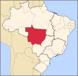
 Location of Pontes e Lacerda | |
| Country | |
| Region | Central-West |
| State | |
| Founded | December 29, 1979 |
| Government | |
| • Mayor | Alcino Pereira Barcelos (2021-2024) |
| Population (2020 [1]) | |
• Total | 45,774 |
| Time zone | UTC−3 (BRT) |
Pontes e Lacerda is a municipality in the Brazilian state of Mato Grosso.
Location
Pontes e Lacerda is located 450 km from Cuiabá, at a latitude 15° 13'34" south and a longitude 59° 20'07" west, with an altitude of 254 meters. Its estimated population in 2020 was 45,774 inhabitants. It has an area of 8,423 square kilometers.
The municipality contains 73% of the 120,092 hectares (296,750 acres) Serra de Santa Bárbara State Park, created in 1997.[2]
Transportation
The city is served by Pontes e Lacerda Airport.
References
- ^ IBGE 2020
- ^ PES Serra de Santa Bárbara (in Portuguese), ISA: Instituto Socioambiental, retrieved 2016-08-04
{{citation}}: CS1 maint: publisher location (link)
15°13′33″S 59°20′06″W / 15.22583334°S 59.335000°W
Capital: Cuiabá | |||||||||||||||||
| Centro-Sul Mato-Grossense |
|  | |||||||||||||||
| Nordeste Mato-Grossense |
| ||||||||||||||||
| Norte Mato-Grossense |
| ||||||||||||||||
| Sudeste Mato-Grossense |
| ||||||||||||||||
| Sudoeste Mato-Grossense |
| ||||||||||||||||