Ronneburg, Thuringia
Ronneburg | |
|---|---|
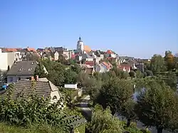 Old town of Ronneburg | |
.png) Coat of arms | |
Location of Ronneburg within Greiz district 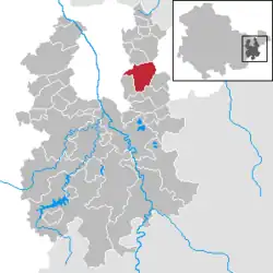 | |
 Ronneburg  Ronneburg | |
| Coordinates: 50°51′49″N 12°10′51″E / 50.86361°N 12.18083°E | |
| Country | Germany |
| State | Thuringia |
| District | Greiz |
| Subdivisions | 4 |
| Government | |
| • Mayor (2024–30) | André Rüderisch[1] |
| Area | |
• Total | 19.13 km2 (7.39 sq mi) |
| Elevation | 280 m (920 ft) |
| Population (2024-12-31)[2] | |
• Total | 4,971 |
| • Density | 260/km2 (670/sq mi) |
| Time zone | UTC+01:00 (CET) |
| • Summer (DST) | UTC+02:00 (CEST) |
| Postal codes | 07580 |
| Dialling codes | 036602 |
| Vehicle registration | GRZ |
| Website | www.ronneburg.de |
Ronneburg (German: [ˈʁɔnəˌbʊʁk] ⓘ) is a town in the district of Greiz, in Thuringia, Germany. It is situated 7 km east of Gera.
History
Within the German Empire (1871–1918), Ronneburg was part of the Duchy of Saxe-Altenburg.
References
- ^ Gewählte Bürgermeister - aktuelle Landesübersicht, Freistaat Thüringen. Retrieved 25 June 2024.
- ^ "Bevölkerung der Gemeinden vom Thüringer Landesamt für Statistik" (in German). Thüringer Landesamt für Statistik.
External links