Sagron Mis
Sagron Mis | |
|---|---|
| Comune di Sagron Mis | |
Location of Sagron Mis | |
 Sagron Mis Location of Sagron Mis in Italy 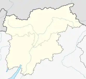 Sagron Mis Sagron Mis (Trentino-Alto Adige/Südtirol) | |
| Coordinates: 46°12′N 11°57′E / 46.200°N 11.950°E | |
| Country | Italy |
| Region | Trentino-Alto Adige/Südtirol |
| Province | Trentino (TN) |
| Frazioni | Matiuz, Pante, Vori |
| Area | |
• Total | 11.2 km2 (4.3 sq mi) |
| Elevation | 1,066 m (3,497 ft) |
| Population (Dec. 2004)[2] | |
• Total | 211 |
| • Density | 19/km2 (49/sq mi) |
| Demonym | Gnodoli |
| Time zone | UTC+1 (CET) |
| • Summer (DST) | UTC+2 (CEST) |
| Postal code | 38050 |
| Dialing code | 0439 |
Sagron Mis (Sagrón in local dialect) is a comune (municipality) in Trentino in the northern Italian region Trentino-Alto Adige/Südtirol, located about 70 kilometres (43 mi) east of Trento. As of 31 December 2004, it had a population of 211 and an area of 11.2 square kilometres (4.3 sq mi).[3]
The municipality of Sagron Mis contains the frazioni (subdivisions, mainly villages and hamlets) Matiuz, Pante (Penns) and Vori.
Sagron Mis borders the following municipalities: Gosaldo, Cesiomaggiore, Tonadico and Transacqua.
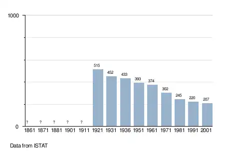
Demographic evolution
References
- ^ "Superficie di Comuni Province e Regioni italiane al 9 ottobre 2011". Italian National Institute of Statistics. Retrieved 16 March 2019.
- ^ "Popolazione Residente al 1° Gennaio 2018". Italian National Institute of Statistics. Retrieved 16 March 2019.
- ^ All demographics and other statistics: Italian statistical institute Istat.