St. Martin am Tennengebirge
St. Martin am Tennengebirge | |
|---|---|
 | |
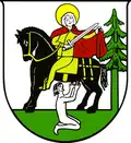 Coat of arms | |
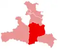
 St. Martin am Tennengebirge Location within Austria | |
| Coordinates: 47°27′53″N 13°22′50″E / 47.46472°N 13.38056°E | |
| Country | Austria |
| State | Salzburg |
| District | St. Johann im Pongau |
| Government | |
| • Mayor | Johannes Schlager (ÖVP) |
| Area | |
• Total | 46.8 km2 (18.1 sq mi) |
| Elevation | 949 m (3,114 ft) |
| Population (2018-01-01)[2] | |
• Total | 1,666 |
| • Density | 36/km2 (92/sq mi) |
| Time zone | UTC+1 (CET) |
| • Summer (DST) | UTC+2 (CEST) |
| Postal code | 5522 |
| Area code | 06463 |
| Vehicle registration | JO |
| Website | www.sanktmartin.at |
St. Martin am Tennengebirge is a municipality in the St. Johann im Pongau district in the Austrian state of Salzburg.
Geography
The village is located in the Ennspongau of the Salzburger Land, in a side valley of the Fritztal, between the southern foot of the Tennen Mountains and the Gerzkopf, a foothill of the Dachstein massif. It also belongs to the Lammertal region, in which it has shares, and to which it represents the valley pass.
Culture and places of interest
- Parish church of St. Martin am Tennengebirge, Gothic hall church of the 1430s with Baroque interior.
References
- ^ "Dauersiedlungsraum der Gemeinden Politischen Bezirke und Bundesländer - Gebietsstand 1.1.2018". Statistics Austria. Retrieved 10 March 2019.
- ^ "Einwohnerzahl 1.1.2018 nach Gemeinden mit Status, Gebietsstand 1.1.2018". Statistics Austria. Retrieved 9 March 2019.
Gallery
-
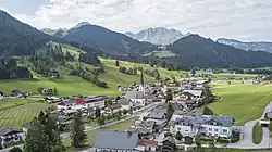
 Sankt Martin am Tennengebirge, view to the village