Sawback Range
| Sawback Range | |
|---|---|
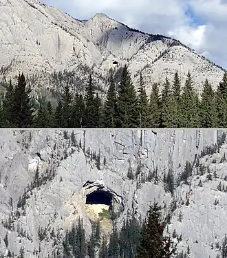 The "Hole in the Wall" is a natural cave on the side of Mount Cory. It is visible from the Trans-Canada Highway. | |
| Highest point | |
| Peak | Mount St. Bride[1] |
| Elevation | 3,315 m (10,876 ft)[2] |
| Coordinates | 51°30′28″N 115°57′19″W / 51.50778°N 115.95528°W[3] |
| Dimensions | |
| Length | 45 km (28 mi) N-S |
| Width | 34 km (21 mi) E-W |
| Area | 622 km2 (240 sq mi)[1] |
| Geography | |
 Sawback Range Location in Alberta | |
| Country | Canada |
| Province | Alberta |
| Range coordinates | 51°21′N 115°50′W / 51.350°N 115.833°W[4] |
| Parent range | Canadian Rockies |
| Topo map | NTS 82O5 Castle Mountain[4] |
The Sawback Range is a mountain range of the Canadian Rockies that stretches from the Bow Valley in Alberta into southeastern Banff National Park.
List of Mountains
This range includes the following mountains and peaks:[5]
See also
References
- ^ a b "Sawback Range". Peakbagger.com. Retrieved 2012-05-19.
- ^ "Topographic map of Mount St. Bride". opentopomap.org. Retrieved 2023-07-24.
- ^ "Mount St. Bride". Geographical Names Data Base. Natural Resources Canada. Retrieved 2023-07-24.
- ^ a b "Sawback Range". Geographical Names Data Base. Natural Resources Canada. Retrieved 2022-08-25.
- ^ "Peaks of the Sawback Range". cdnrockiesdatabases.ca. Retrieved 2023-06-07.