Wienerwald, Austria
Wienerwald
Weanawoid | |
|---|---|
.JPG) Wildegg Castle | |
 Coat of arms | |
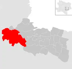
 Wienerwald Location within Austria | |
| Coordinates: 48°6′N 16°8′E / 48.100°N 16.133°E | |
| Country | Austria |
| State | Lower Austria |
| District | Mödling |
| Government | |
| • Mayor | Michael Krischke (ÖVP) |
| Area | |
• Total | 48.17 km2 (18.60 sq mi) |
| Elevation | 340 m (1,120 ft) |
| Population (2018-01-01)[2] | |
• Total | 2,858 |
| • Density | 59/km2 (150/sq mi) |
| Time zone | UTC+1 (CET) |
| • Summer (DST) | UTC+2 (CEST) |
| Postal code | 2392 |
| Area code | 02238 |
| Website | http://www.gemeinde-wienerwald.at/ |
Wienerwald (Central Bavarian: Weanawoid) is a municipality in the district of Mödling in the Austrian state of Lower Austria. It is named after the forest Wienerwald.
Villages
- Ameisbühel
- Buchelbach
- Dornbach
- Festleiten
- Grub
- Gruberau
- Lindenhof
- Rohrberg
- Sittendorf
- Stangau
- Sulz im Wienerwald
- Vogelgraben
- Wöglerin
Population
| Year | Pop. | ±% |
|---|---|---|
| 1971 | 1,381 | — |
| 1981 | 1,553 | +12.5% |
| 1991 | 1,996 | +28.5% |
| 2001 | 2,409 | +20.7% |
| 2011 | 2,479 | +2.9% |
Sights
- Wildegg Castle in Sittendorf
References
- ^ "Dauersiedlungsraum der Gemeinden Politischen Bezirke und Bundesländer - Gebietsstand 1.1.2018". Statistics Austria. Retrieved 10 March 2019.
- ^ "Einwohnerzahl 1.1.2018 nach Gemeinden mit Status, Gebietsstand 1.1.2018". Statistics Austria. Retrieved 9 March 2019.
External links
 Media related to Wienerwald (municipality) at Wikimedia Commons