Slaty Fork, West Virginia
Slatyfork, West Virginia | |
|---|---|
 Slatyfork, West Virginia  Slatyfork, West Virginia | |
| Coordinates: 38°24′59″N 80°07′36″W / 38.41639°N 80.12667°W | |
| Country | United States |
| State | West Virginia |
| County | Pocahontas |
| Elevation | 2,684 ft (818 m) |
| Time zone | UTC-5 (Eastern (EST)) |
| • Summer (DST) | UTC-4 (EDT) |
| ZIP code | 26291[1] |
| Area codes | 304 & 681 |
| GNIS feature ID | 1552924[2] |
Slatyfork is an unincorporated community in Pocahontas County, West Virginia, United States. Slatyfork is located along U.S. Route 219, 13.5 miles (21.7 km) north of Marlinton.
A variant name was Laurel Bank.[3]
A large cave known as Sharps Cave is located in Slatyfork.[4]
References
- ^ "Slatyfork ZIP Code". zipdatamaps.com. 2022. Retrieved November 30, 2022.
- ^ "US Board on Geographic Names". United States Geological Survey. October 25, 2007. Retrieved January 31, 2008.
- ^ Kenny, Hamill (1945). West Virginia Place Names: Their Origin and Meaning, Including the Nomenclature of the Streams and Mountains. Piedmont, WV: The Place Name Press. p. 586.
- ^ National Speleological Society (1977). The NSS Bulletin.
Municipalities and communities of Pocahontas County, West Virginia, United States | ||
|---|---|---|
| Towns | 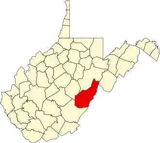 | |
| CDPs | ||
| Unincorporated communities |
| |
| Ghost towns | ||