Slavče
Slavče | |
|---|---|
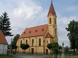 Church of Saints Philip and James | |
 Slavče Location in the Czech Republic | |
| Coordinates: 48°47′53″N 14°36′54″E / 48.79806°N 14.61500°E | |
| Country | |
| Region | South Bohemian |
| District | České Budějovice |
| First mentioned | 1394 |
| Area | |
• Total | 16.27 km2 (6.28 sq mi) |
| Elevation | 568 m (1,864 ft) |
| Population (2025-01-01)[1] | |
• Total | 742 |
| • Density | 46/km2 (120/sq mi) |
| Time zone | UTC+1 (CET) |
| • Summer (DST) | UTC+2 (CEST) |
| Postal code | 373 21 |
| Website | www |
Slavče is a municipality and village in České Budějovice District in the South Bohemian Region of the Czech Republic. It has about 700 inhabitants.
Slavče lies approximately 23 kilometres (14 mi) south-east of České Budějovice and 144 km (89 mi) south of Prague.
Administrative division
Slavče consists of six municipal parts (in brackets population according to the 2021 census):[2]
- Slavče (383)
- Dobrkovská Lhotka (125)
- Keblany (56)
- Lniště (27)
- Mohuřice (83)
- Záluží (11)
Demographics
| Year | Pop. | ±% |
|---|---|---|
| 1869 | 1,056 | — |
| 1880 | 1,212 | +14.8% |
| 1890 | 1,253 | +3.4% |
| 1900 | 1,239 | −1.1% |
| 1910 | 1,329 | +7.3% |
| 1921 | 1,291 | −2.9% |
| 1930 | 1,169 | −9.5% |
| 1950 | 751 | −35.8% |
| 1961 | 702 | −6.5% |
| 1970 | 620 | −11.7% |
| 1980 | 524 | −15.5% |
| 1991 | 497 | −5.2% |
| 2001 | 515 | +3.6% |
| 2011 | 581 | +12.8% |
| 2021 | 685 | +17.9% |
| Source: Censuses[3][4] | ||
References
- ^ "Population of Municipalities – 1 January 2025". Czech Statistical Office. 2025-05-16.
- ^ "Public Census 2021 – basic data". Public Database (in Czech). Czech Statistical Office. 2022.
- ^ "Historický lexikon obcí České republiky 1869–2011" (in Czech). Czech Statistical Office. 2015-12-21.
- ^ "Population Census 2021: Population by sex". Public Database. Czech Statistical Office. 2021-03-27.
External links
Wikimedia Commons has media related to Slavče.