Szatta
Szatta | |
|---|---|
Village | |
 | |
 Flag 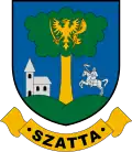 Coat of arms | |
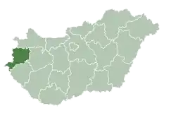
 Szatta Location of Szatta | |
| Coordinates: 46°47′53″N 16°28′48″E / 46.79792°N 16.48008°E | |
| Country | Hungary |
| Region | Western Transdanubia |
| County | Vas |
| District | Körmend |
| Area | |
• Total | 6.01 km2 (2.32 sq mi) |
| Population (1 January 2024)[1] | |
• Total | 65 |
| • Density | 11/km2 (28/sq mi) |
| Time zone | UTC+1 (CET) |
| • Summer (DST) | UTC+2 (CEST) |
| Postal code | 9938 |
| Area code | (+36) 94 |
| Website | www |
Szatta is a village in Vas county, Hungary.
References
External links