Tsarabaria
Tsarabaria | |
|---|---|
 | |
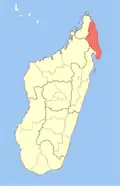
 Tsarabaria Location in Madagascar | |
| Coordinates: 13°45′S 49°57′E / 13.750°S 49.950°E | |
| Country | |
| Region | Sava |
| District | Vohemar |
| Elevation | 39 m (128 ft) |
| Population (2001)[2] | |
• Total | 20,000 |
| Time zone | UTC3 (EAT) |
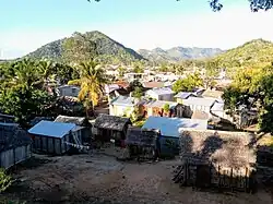
Tsarabaria is a rural municipality in northern Madagascar. It belongs to the district of Vohemar, which is a part of Sava Region. The population of the commune was estimated to be approximately 20,000 in 2001 commune census.[2]
Primary and junior level secondary education are available. It is also a site of industrial-scale mining. The majority 99% of the population of the commune are farmers. The most important crops are coffee and vanilla, while other important agricultural products are beans and rice. Industry provides employment for 0.9% of the population. Additionally fishing employs 0.1% of the population.[2]
Geography
The town is situated at the Route nationale 5a between Vohemar and Sambava.
References
- ^ Estimated based on DEM data from Shuttle Radar Topography Mission
- ^ a b c "ILO census data". Cornell University. 2002. Retrieved 2008-02-25.
Wikimedia Commons has media related to Tsarabaria.