Tvrdkov
Tvrdkov | |
|---|---|
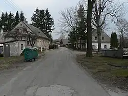 Centre of Tvrdkov | |
 Coat of arms | |
 Tvrdkov Location in the Czech Republic | |
| Coordinates: 49°53′44″N 17°10′41″E / 49.89556°N 17.17806°E | |
| Country | |
| Region | Moravian-Silesian |
| District | Bruntál |
| First mentioned | 1349 |
| Area | |
• Total | 19.89 km2 (7.68 sq mi) |
| Elevation | 495 m (1,624 ft) |
| Population (2025-01-01)[1] | |
• Total | 238 |
| • Density | 12/km2 (31/sq mi) |
| Time zone | UTC+1 (CET) |
| • Summer (DST) | UTC+2 (CEST) |
| Postal code | 793 44 |
| Website | www |
Tvrdkov (German: Pürkau) is a municipality and village in Bruntál District in the Moravian-Silesian Region of the Czech Republic. It has about 200 inhabitants.
Administrative division
Tvrdkov consists of three municipal parts (in brackets population according to the 2021 census):[2]
- Tvrdkov (127)
- Mirotínek (22)
- Ruda (78)
Demographics
| Year | Pop. | ±% |
|---|---|---|
| 1869 | 1,647 | — |
| 1880 | 1,638 | −0.5% |
| 1890 | 1,524 | −7.0% |
| 1900 | 1,377 | −9.6% |
| 1910 | 1,302 | −5.4% |
| 1921 | 1,227 | −5.8% |
| 1930 | 1,148 | −6.4% |
| 1950 | 527 | −54.1% |
| 1961 | 571 | +8.3% |
| 1970 | 473 | −17.2% |
| 1980 | 346 | −26.8% |
| 1991 | 287 | −17.1% |
| 2001 | 253 | −11.8% |
| 2011 | 216 | −14.6% |
| 2021 | 227 | +5.1% |
| Source: Censuses[3][4] | ||
References
- ^ "Population of Municipalities – 1 January 2025". Czech Statistical Office. 2025-05-16.
- ^ "Public Census 2021 – basic data". Public Database (in Czech). Czech Statistical Office. 2022.
- ^ "Historický lexikon obcí České republiky 1869–2011" (in Czech). Czech Statistical Office. 2015-12-21.
- ^ "Population Census 2021: Population by sex". Public Database. Czech Statistical Office. 2021-03-27.
External links
Wikimedia Commons has media related to Tvrdkov.