Virming
Virming | |
|---|---|
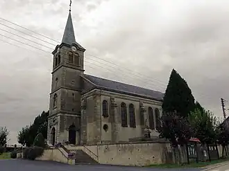 The church in Virming | |
 Coat of arms | |
Location of Virming | |
 Virming  Virming | |
| Coordinates: 48°56′46″N 6°45′06″E / 48.9461°N 6.7517°E | |
| Country | France |
| Region | Grand Est |
| Department | Moselle |
| Arrondissement | Sarrebourg-Château-Salins |
| Canton | Le Saulnois |
| Intercommunality | CC du Saulnois |
| Government | |
| • Mayor (2020–2026) | Yolande Houpert[1] |
Area 1 | 10.77 km2 (4.16 sq mi) |
| Population (2022)[2] | 295 |
| • Density | 27/km2 (71/sq mi) |
| Time zone | UTC+01:00 (CET) |
| • Summer (DST) | UTC+02:00 (CEST) |
| INSEE/Postal code | 57723 /57340 |
| Elevation | 221–266 m (725–873 ft) (avg. 215 m or 705 ft) |
| 1 French Land Register data, which excludes lakes, ponds, glaciers > 1 km2 (0.386 sq mi or 247 acres) and river estuaries. | |
Virming (French pronunciation: [viʁmɛ̃]; German: Wirmingen; Lorraine Franconian Wirminge) is a commune in the Moselle department in Grand Est in north-eastern France.
History
Dependence of the ancient manor of Lorraine. Completely destroyed during the Thirty Years' War and resettled in 1656. The village was destroyed for 80% in 1944 and rebuilt in 1950.
See also
References
- ^ "Répertoire national des élus: les maires". data.gouv.fr, Plateforme ouverte des données publiques françaises (in French). 2 December 2020.
- ^ "Populations de référence 2022" (in French). The National Institute of Statistics and Economic Studies. 19 December 2024.
External links
 Media related to Virming at Wikimedia Commons