Voueize
| Voueize | |
|---|---|
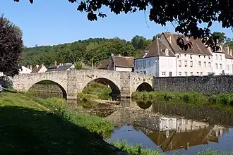 The Voueize at Chambon-sur-Voueize | |
  | |
| Location | |
| Country | France |
| Physical characteristics | |
| Source | |
| • location | La Chaussade |
| • coordinates | 45°59′25″N 02°14′39″E / 45.99028°N 2.24417°E |
| • elevation | 590 m (1,940 ft) |
| Mouth | |
• location | Tardes |
• coordinates | 46°11′17″N 02°25′18″E / 46.18806°N 2.42167°E |
• elevation | 330 m (1,080 ft) |
| Length | 53.6 km (33.3 mi) |
| Basin size | 435 km2 (168 sq mi) |
| Basin features | |
| Progression | Tardes→ Cher→ Loire→ Atlantic Ocean |
The Voueize (French pronunciation: [vwɛz]; Occitan: Voeisa) is a 53.6-kilometre-long (33.3 mi) river in the Creuse département, central France.[1] Its source is at La Chaussade. It flows generally northeast. It is a left tributary of the Tardes into which it flows at Chambon-sur-Voueize.
Communes along its course
This list is ordered from source to mouth: La Chaussade, Bosroger, Champagnat, Puy-Malsignat, Peyrat-la-Nonière, Saint-Julien-le-Châtel, Saint-Loup, Pierrefitte, Gouzon, Bord-Saint-Georges, Lussat, Lépaud, Chambon-sur-Voueize
References
Wikimedia Commons has media related to Voueize.