Wagon Wheel, Arizona
Wagon Wheel, Arizona | |
|---|---|
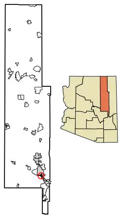 Location of Wagon Wheel in Navajo County, Arizona. | |
 Wagon Wheel, Arizona Location in the United States | |
| Coordinates: 34°11′51″N 110°01′38″W / 34.19750°N 110.02722°W | |
| Country | United States |
| State | Arizona |
| County | Navajo |
| Government | |
| • Mayor | Straw Tim |
| Area | |
• Total | 2.53 sq mi (6.56 km2) |
| • Land | 2.53 sq mi (6.56 km2) |
| • Water | 0.00 sq mi (0.00 km2) |
| Elevation | 6,641 ft (2,024 m) |
| Population (2020) | |
• Total | 1,856 |
| • Density | 732.44/sq mi (282.85/km2) |
| Time zone | UTC-7 (MST (no DST)) |
| FIPS code | 04-80380 |
| GNIS feature ID | 2582893[2] |
Wagon Wheel is a census-designated place in Navajo County, in the U.S. state of Arizona.[2] The population was 1,652 at the 2010 census.[3] It is located between Show Low and Pinetop-Lakeside.
Demographics
| Census | Pop. | Note | %± |
|---|---|---|---|
| 2010 | 1,652 | — | |
| 2020 | 1,856 | 12.3% | |
| U.S. Decennial Census[4] | |||
As of the census[5] of 2010, there were 1,652 people, 680 households, and 434 families living in the CDP.
References
- ^ "2020 U.S. Gazetteer Files". United States Census Bureau. Retrieved October 29, 2021.
- ^ a b c U.S. Geological Survey Geographic Names Information System: Wagon Wheel, Arizona
- ^ "2010 Census Gazetteer Files – Places: New Mexico". U.S. Census Bureau. Retrieved February 26, 2017.
- ^ "Census of Population and Housing". Census.gov. Retrieved June 4, 2016.
- ^ "American FactFinder". United States Census Bureau. Archived from the original on February 13, 2020. Retrieved October 10, 2018.
