Windsor, Indiana
Windsor, Indiana | |
|---|---|
 Windsor  Windsor | |
| Coordinates: 40°09′22″N 85°12′57″W / 40.15611°N 85.21583°W | |
| Country | |
| State | |
| Counties | Randolph, Delaware |
| Townships | Stoney Creek, Liberty |
| Founded | January 30, 1832 |
| Elevation | 310 m (1,017 ft) |
| Time zone | UTC-5 (Eastern (EST)) |
| • Summer (DST) | UTC-4 (EDT) |
| ZIP code | 47368 |
| Area code | 765 |
| GNIS feature ID | 2830360[1] |
Windsor is an unincorporated community and census-designated place (CDP) in Randolph and Delaware counties, in the U.S. state of Indiana.[1]
History
Windsor was laid out on January 30, 1832.[2] The community most likely was named after Windsor Castle.[3] A post office was established at Windsor in 1831, and remained in operation until it was discontinued in 1898.[4]
Demographics
| Census | Pop. | Note | %± |
|---|---|---|---|
| 2023 (est.) | 0 | [5] |
The United States Census Bureau defined Windsor as a census designated place in the 2022 American Community Survey.[6]
References
- ^ a b c U.S. Geological Survey Geographic Names Information System: Windsor, Indiana
- ^ Baker, Ronald L. (1995). From Needmore to Prosperity : Hoosier place names in folklore and history. Internet Archive. Bloomington : Indiana University Press. p. 350. ISBN 978-0-253-32866-3.
{{cite book}}: CS1 maint: publisher location (link) - ^ Baker, Ronald L. (October 1995). From Needmore to Prosperity: Hoosier Place Names in Folklore and History. Indiana University Press. p. 350. ISBN 978-0-253-32866-3.
...name is for the castle in England.
- ^ "Randolph County". Jim Forte Postal History. Retrieved November 1, 2015.
- ^ "B03002 Hispanic or Latino, and Not Hispanic or Latino by Race – Windsor CDP – 2023 American Community Survey 5-Year Estimates". U.S. Census Bureau. July 1, 2023. Retrieved August 1, 2025.
- ^ "2022 Geography Changes". United States Census Bureau.
Municipalities and communities of Randolph County, Indiana, United States | ||
|---|---|---|
| Cities | 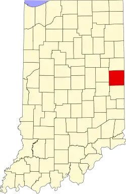 | |
| Towns | ||
| Townships | ||
| CDPs | ||
| Farming settlements | ||
| Other communities | ||
| Footnotes | ‡This populated place also has portions in an adjacent county or counties | |
Municipalities and communities of Delaware County, Indiana, United States | ||
|---|---|---|
| City |  | |
| Towns | ||
| Townships | ||
| CDPs | ||
| Other communities | ||
| Footnotes | ‡This populated place also has portions in an adjacent county or counties | |