Wolfern
Wolfern | |
|---|---|
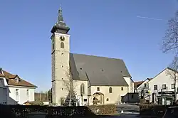 Catholic parish church of Saint Martin in Wolfern | |
 Coat of arms | |
 Wolfern Location within Austria | |
| Coordinates: 48°05′00″N 14°22′29″E / 48.08333°N 14.37472°E | |
| Country | Austria |
| State | Upper Austria |
| District | Steyr-Land |
| Government | |
| • Mayor | Franz Schillhuber (ÖVP) |
| Area | |
• Total | 32.58 km2 (12.58 sq mi) |
| Elevation | 359 m (1,178 ft) |
| Population (2018-01-01)[2] | |
• Total | 3,173 |
| • Density | 97/km2 (250/sq mi) |
| Time zone | UTC+1 (CET) |
| • Summer (DST) | UTC+2 (CEST) |
| Postal code | 4493 |
| Area code | 07253 |
| Vehicle registration | SE |
| Website | www.wolfern.at |
Wolfern is a municipality in the district of Steyr-Land in the Austrian state of Upper Austria. It is a third-order administrative region in Politischer Bezirk Steyr-Land.
Geography
About 14 percent of the municipality is forest, and 77 percent is farmland.
References
- ^ "Dauersiedlungsraum der Gemeinden Politischen Bezirke und Bundesländer - Gebietsstand 1.1.2018". Statistics Austria. Retrieved 10 March 2019.
- ^ "Einwohnerzahl 1.1.2018 nach Gemeinden mit Status, Gebietsstand 1.1.2018". Statistics Austria. Retrieved 9 March 2019.
Wikimedia Commons has media related to Wolfern.